Camp 1 Nandal
- Related Topics How to Climb Camp 1 Polour Hut
Nandal Mountaineer House in Nandal Village
Mountain climbers can meet up in the Nandal camp or Nandel's climbing lodge (Nandal mountaineering house), which offers amenities like lodging and restrooms. If they are travelling north or northeast of Mount Damavand. At the Nandal resort or Mountaineers' residence in Nandal village, you can arrange for drinking water, a vehicle to take you to the starting point of your hike, the Big Stone, and a mule to transport your equipment to the mountain campgrounds.

Mount Damavand Iran aerial view
The Mountaineering House at Nandal Village
A two-story residence nearby in Nandal's mountaineer's home community is a place where climbers can find shelter. There are 20 climbers who can stay in this house. In the Nandal climbing house, you are under the direction of a man by the name of Mr. Salehi. If you are going with a larger party, he may assist you with reserving another village house in the Nandal village for your team. Mountaineers without a planned itinerary may spend a day here to strenght their physical fitness and get acclimated to being in the 2,700-meter-high village of Nandal before trying the Damavand summit. It is also suggested that you visit the local farms and scenic areas.

Mountaineers' Camp in Nandel Village
Mr. Salehi local house in Damavand North face
Guide to Hiking Damavand
Camp and Mountaineering Resort Nandal
There are other names for Nandal Camp, including Nandal resort, Nandal mountain house, Nandal climber house, and Nandal house, Mountaineering camp and resort Nandal. As well as Nandal Camp, other names for it include Nandal resort, Nandal mountain house, Nandal climber house in Nandal Village.

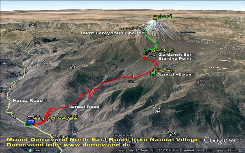
Nandal Village, Damavand north and north-east routes' starting point
Village of Nandal
The Damavand North and North-East Routes' Starting Point
The charming village of Nandal, which is situated at a height of 2,300 meters above sea level, is one of the Larijan settlements in the county of Amol in the province of Mazandaran. The Haraz Road runs alongside the summer village of Nandal. This village, which is separated from the Haraz Road by a side road, is situated around 50 kilometers from the city of Amol and 140 kilometers from Tehran's center. The distance between Nandel Village and Haraz Road Junction is roughly 15 kilometers.

Mount Damavand climbing guide: north-east route - Nandal trail
Because Nandal is one of the best and most well-known routes to the top, mountaineers trek there to climb Mount Damavand's northeast or northern face. Many tourists can travel to the area with the aid of a Damavand trekking guide.
Iran's Damavand region, to the northeast, has breathtaking beauty. It has plenty of water and plants. The mountain's north face of Damavand is also more difficult to approach than the other sides. Rare species, like those in Nandal resort, live there as a result to avoid being devoured by predators. All these wonders have transformed the northern slope of Damavand into a pure and dynamic region.

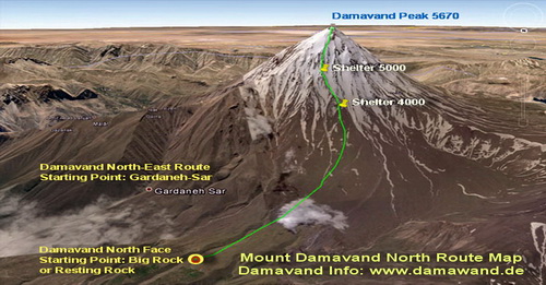
Mount Damavand climbing guide: north face route map
Nandal Village North Face of Damavand
Damavand Hiking Trekking Guide Nandal Village, North Face of Damavand, and Starting Points for the North and North-East Routes of Damavand
Starting Point for the Damavand North and North-East Routes
For mountaineers, Nandal village acts as a starting point. Climbers start their ascent at Nandal village if they want to ascend Damavand peak from the north or northeast side. To climb the northeast face of the Damavand, you must first travel to Nandal. In fact, mountain climbers consider it to be one of the best and most beautiful routes.
A- Damavand North and North-East faces
mountaineers' Camp in Nandel Village, Mr. Salehi
Local residence: Height 2350 meters
Coordinates:
Longitude: 52.174072, latitude: 36.030330

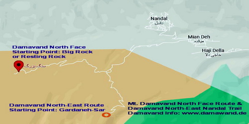
The Big Stone - Mount Damavand North Route Starting Point
B- The Big Stone
The Big Stone Mount Damavand North Route Starting Point
Camping area: Summer Base
Tenting area - 2920 meters in height
Coordinates:
Longitude: 52.120590 and latitude 36.011929
Mobile service on Mount Damavand's northeastern side
Mobile Network services are available from Takht-e Fereydoun shelter to the Gardneh-Sar sheepfold (Irancell and the Hamrah-Avval).
You can let Mr. Salehi, who oversees the mountaineers' camp in Nandel Village, know what time to come after you in a 4WD car and drive you back to Nandal.

Damavand climbing instruction north face
Helpful people in the area
Mr. Salehi and the Nandel mountaineer house. Tel: +981223422226
Mr. Hoshang Salehi (responsible for mountaineer house).
Nissan 4WD driver Ismail Ramezani. Tel: +989119180618
Qanbari Ali (owner of the mules). Tel: +989119155088
Climate in Nandal
Nandal's weather is frigid, similar to the temperature of the Damavand mountains. Due to the area's slopes, it receives pleasant spring rainfall. Because of the good weather and the splendor of the Damavand mountain with its white glaciers, this place attracts a lot of tourists and nature enthusiasts. Clouds and fog cover the landscape of Nandal Village all year long. Extremely pure nandle water is said by experts to rid the body of salts that have accumulated in the kidneys. A vast range of edible and medicinal plants and vegetables may be found in Nandal.

Climbing guide Damavand mountain, Iran
Access to the Nandal village
Drive To Damavand North and North-East
Highway leading to Nandal Village Mountaineering Resort. Guide to Damavand Trekking
To Damavand North and North-East. Road leading to Nandal Village Mountain Resort
Driving Guide to Damavand Mountain
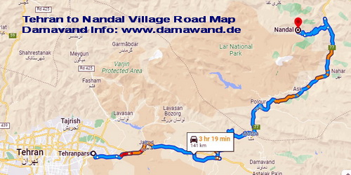
From Tehran, take the road to Haraz, and then travel farther. A route going to the hamlet of Nandal will be evident on the left after passing through the village of Polour, Gaznak, Vana Tunnel, Baijan, and Kalantari. After passing through Tunnel 8 and the Baijan Police Station, a sign pointing you in the direction of Nandal Mountaineering House is located on the left. Continue along the road until you reach the lovely village of Nandel.
Drive to Damavand North & North-East in accordance with the directions on the Mount Damavand Northe & North-east Face road map for the Damavand climbing and trekking guide. Nandal Village Mountaineering Resort's access road. Drive to Damavand North and take the North-East Road to Nandal Village Mountaineering Resort.

Trekking tour guide Damavand Iran
Tehran to Nandal village road map
Nearby Nandal waterfall
The tall rock from which the Nandal waterfall flows is built into the lowest part of the metal bridge. Nandal waterfall is located in Nandal village, so you must take the same route that leads there in order to get there. Take Haraz Road between tunnels 7 and 8. A trail on the west side of the road runs between these tunnels and leads to the villages of Hajidella, Miandeh, Rezen, Kerf, and ultimately Nandal. So be sure to visit the cool Nandal waterfall while you're there.
Lagh Lehr is one of the activities available in the Nandal area.
This village, which is located in Lower Larijan Village, was last counted by the Iran Statistics Center in 2005, and it had a population of 37 people (12 houses). Its population can rise to 400 persons during the summer because of the great climate. Among its breathtaking and amazing attractions are the Imamzadeh of Abbas and Ali (AS), Gardkala, Nal Pi, Spion, Kamron, Dast Brun, Loser, the lovely Sarkh Tali woods, the Gully Gorge, and the Zaraviz region. The distance between Lehar hamlet and Amol city is around 60 kilometers, of which 52 kilometers are on asphalt and 8 kilometers are on dirt. It is located between the towns of Fes and Nandal and is 2450 meters above sea level.
National Register for Nandal Amol Village
Iran's natural heritage has been acknowledged, introduced, and registered by the Iranian Cultural Heritage Organization. This heritage consists of the country's natural geographic regions and special areas, which have been identified and are protected due to their exceptional physical and biological qualities, distinctive geographic landscapes, and significant natural and historic regions, phenomena, and examples of plants, animals, and their habitats. The mountain with the addresses of Amol city, Larijan region, and Upper Larijan part, which looks down over Rineh and the villages of Ask, Gazanak, Polour, and Nandel, was listed as a cultural historic site in 2007.

Climbing tour guide mount Damavand Iran
Damavand north face road map

Mount Damavand Iran +++

Hiking trekking guide Mount Damavand Iran
Mount Damavand Explained: Location, Height, Rankings, and Everything You Need to Know
Mount Damavand is an iconic mountain that has captivated the hearts of adventurers for centuries. Located in the Alborz mountain range in northern Iran, it holds the title of the highest peak in the Middle East at 5,671 meters. This detailed explanation covers everything you need to know, including the mountain's geographical location, its global ranking, and the significance it holds both in nature and culture. Whether you're planning a climb or simply fascinated by its grandeur, this guide provides all the essential details.
Damavand Base Camp
9. Goosfand Sara Campsite, widely recognized as Damavand Base Camp, is the easiest and most notable launch site for Mount Damavand climbs in Iran. Located at 3,040 meters, the site includes a modest refuge, a mosque named Saheb al Zaman, and a sheepfold. It serves as the main base for treks up the south route during summer, positioned at coordinates 35.9020° N and 52.1094° E.
Damavand Trekking and Climbing Tours
Damavand trekking and climbing tours offer an excellent way to experience the beauty and challenge of Mount Damavand. These tours include expert guides, detailed itineraries, and the best tour packages available for reaching the summit. With trekking tours on Damavand’s South Route and beyond, adventurers can enjoy both the challenge and the spectacular scenery of this famous mountain. Each package is designed to provide you with the necessary skills and knowledge to conquer the peak while enjoying the breathtaking landscapes, creating unforgettable memories during your journey through the heart of Iran.
Expert Damavand Hiking Guides for a Safe Adventure
Damavand Iran Hiking Tour Guide: Professional Expertise for a Safe Climb. A Damavand Iran hiking tour guide brings not only expert climbing skills but also professional expertise in managing group dynamics and ensuring a safe journey for everyone involved. These certified and professional local experts know the mountain intimately, understanding which paths are safest and most scenic. They also play an important role in monitoring your health and energy levels, ensuring that you stay on track and acclimatize properly. With their knowledge, you’ll be able to enjoy the diverse flora, fauna, and striking geological features of Mount Damavand.