Damavand Facts & Info
Mount Damavand Facts & Information
Facts, information, tips, and Guidance for Trekking Damavand, Iran.Useful facts information, tips, and directions for climbing Mount Damavand. All data you need to know about Damavand , including facts, info, weather forecasts, hiking trails, Damavand climbing tours, necessary gear, and more. Damavand is a genuine volcano, there are four well-known hiking routes in addition to the multiple angles from which it can be climbed due to its conical shape.
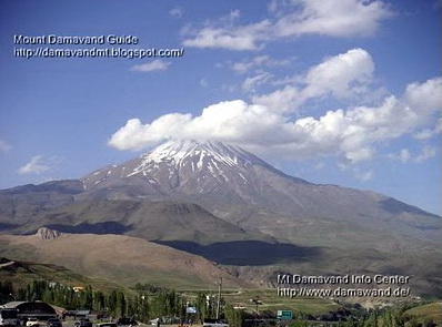
Damavand
Highest Peak in the Middle East 5671m, 18,605 ft
Highest volcano in Asia and the second highest volcano in North Hemisphere
Damavand Facts & Information
Brief facts, information, tips, and Guidance about Mount Damavand, Iran.- Height: 5,670 m, 18,600 feet (see also my personal GPS measurement).
- Listing: Volcanic Seven Summits (V7S).
- Location: Northeast of capital Tehran - Mazandaran Province, Iran.
- Parent peak: Alborz Chain.
- Prominence: 4,667 m. It is ranked the 12th most prominent peak in the world and the second most prominent in Asia after Mount Everest.
- Famous Climbing Routes: The classic southern route, west trail, northeast front, north face.
- Volcanic Activity: At present Damavand volcano only emits sulfuric gas at the top and has hot springs at the slops.
- Summit Coordinates: Lat: 35.954466°, Lon: 52.110020°
- Distance: From Tehran, 80 km drive by road, about 2 hours time.
- Nearest airport: is IKA Airport and Mehrabad Airport, Teheran.
- Last eruption: About 7,300 years ago
- Symbolism: In Persian poetry and literature, it is the representation of Iranian resistance to against the foreign rule.
- Mountain type: Stratovolcano.
- Climbing Routes: South route, West front, North-East side, and the North face.
- Rank: Damavand volcano is ranked 3rd in volcanic seven summits (V7S). It is the highest peak in Persia and the middle east and the highest volcano in Asia and the second highest volcano in the north hemisphere. The topographic prominence of Damavand (summit height vs the lowest valley, Haraz Valley) is 4,667 m. In terms of prominence factor, Damavand mountain is the 12th-highest summit in the world.
Quick Facts, Info and Guide for Trekking Damavand
- Elevation Gain: 2670 meters, 8760 feet. South route Goosfand-Sara base camp to the summit.
- Best Hiking Season: July to September. Visit Timing.
- Best Hiking Program: 3 to 5-day trekking itinerary.
- Best Starting Days: Saturday and Sunday. Visit Crowd.
- Best Starting Damavand Camp: Polour camp for the south and the west routes and Nandal Camp for the north and northeast routes.
- Climbing Season: All year for experienced climbers. Mid-June to mid-September for ordinary climbers.
- Difficulty: The south route Difficulty is a moderate walk-up, easy descent. F, YDS class 2 (+ Sulphur gas above 5,400 m).
- Easiest Hiking Route: The south route in summer is basic hiking and trekking.
- Moderate Trekking Route: West route is basic trekking with moderate walk-up, difficult descend.
- Longest Mountaineering Route: North-east side, Gazaneh trail.
- Hardest Climbing Route: The north face, scramble climbing, steep.
- Trekking Length: The south route base-camp to the summit is 8 Km from (10 hours).
- Most Popular Route: The classic south route.
- Climbing Guide: Damavand Guide Team are the most experienced guiding team for Damavand trekking tours.
Brief Facts and Data for Ski Touring Damavand
Depends to the weather and the amount of snow.- Ski Season & Snow Availability: December to mid-May. Best ski time is March & April.
- Best Ski Touring Route: Damavand south route ski resort.
- Best Ski Touring Program: 7-day itinerary
- Snow Depths: 2 to 5 meters
- Vertical Ski Drop: Optimum about 3000 meters, Summit to asphalt road.
- Total Skiable Distance: Optimum summit to asphalt road: 12000 meters.
- Ski Touring Guide: Damavand Ski Guide Team is the most experienced guiding team for Damavand ski mountaineering & ski touring.
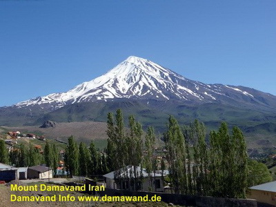
Damavand
Hike Trek Tour Ski Tour Mount Damavand Iran
Summer View from Haraz Road and Polour Village
Photo by Ardeshir Soltani
A Quick Guide for Trekking Damavand
Damavand Interesting Facts
Best source of info for hiking Damavand Mountain, Iran. Visit the country and enjoy an excellent trekking adventure at one of the Volcanic Seven Summits in the world. Mount Damavand, the pinnacle of Iran, is proudly at the top of the list for trekking.For more info you may visit Damavand page.
The ancient Persia is called Iran in the modern era. While amazed by the very ancient history and architecture of Iran, you may forget that Iran also has a breathtaking nature. Mt. Damavand, the roof of Iran, is proudly at the top of the list for climbing. But the best attraction of the country is the hospitality of people which make you feel welcome.
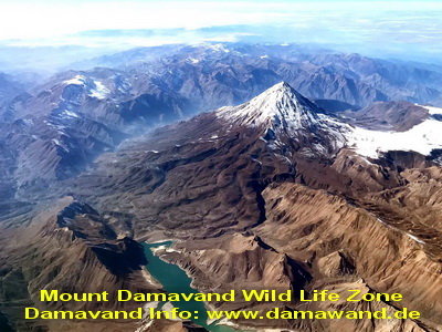
Damavand peak is usually covered in a halo of clouds and plays an important role in Iranian folklore and myths. Damavand is more than one of the amazing natural wonders of the country. In a clear sky Damavand summit is not only visible from Tehran, but also as far as 250 km away. This giant perfect cone-shape volcano is also called Damavand Volcano! It is located in the middle of Alborz Mountain Range in north of Iran on the southern coast of the Caspian Sea. Damavand Mountain height is 5670 meters above sea level (See also Damavand Height by our GPS Measurement). Damavand Volcano is the highest volcanic mountain in Asia and the second highest volcano in the northern hemisphere. Find more data in Damavand Info.
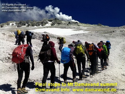
Damavand
Final steps to Damavand Peak
Photo Amir Manian
Snow covers the entire mountain in winter and the upper parts in the other seasons. Damavand (in Persian دماوند) has a narrow summit crater usually covered with snow-cap and cloud. The snowy white peak with its regular Cloud Cap is the most beautiful sight of Iran. Damawand is surrounded by many good looking peaks of the Alborz Chain. The view of this huge mountain looks more attractive from away than close up. In a clear day it is visible far from 250 km.
Learn more about Damavand hiking tours at Mount Damavand tours. It has info on all the essential details.
To understand the scale of Mt. Damavand just travel to Iran for hiking trekking, climbing and skiing on this giant volcano and enjoy an excellent adventure at one of the Volcanic Seven Summits in the world. Damavand is also ranked as the earth's 12th highest Prominence (the scale is Mt Everest in Himalayan). Besides this snow-capped volcano there are many virgin hiking trails, trekking zones, ski mountaineering heights, ski touring areas and ski resorts in Iran.
Mount Damavand is the most prominent feature of Iran looming majestically near the southern coast of the Caspian Sea. It has a narrow summit crater with permanent snowcap which surrounded by many good looking peaks of the Alborz Mountain Range. Climbing Damavand Iran.
Damavand Mountain is visible far from 250 km in a clear sky. Just below its crater there are few famous glaciers such as Yakhar, Sioleh and Dobi Sel. Damavand is located about 80 km north east of capital city Tehran, midway the Haraz Road near the Amol city in Mazandaran Province, Iran.
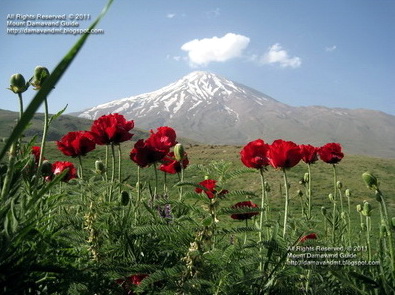
Mount Damavand 5671m, 18,605 ft
Highest Summit in Iran and the Middle East
Second Highest Volcano in Asia and the Northen Hemisphere
Quick Facts for Climbing Damavand
Best Climbing Program: 4 to 5 days.Best Itinerary: 4A or 5B, Visit Itinerary.
Best Start point: Polour Camp, visit GPS Track.
Best Starting Days: Saturday, Sunday and Monday, Visit Crowd.
Best Climbing Time: 15 June To 20 August. See Timing.
Best Climbing Side: South Route, See How to Climb, Routes.
Best Place for Accommodation: Camp1 Polour.
Best Camp for Acclimatization: Camp3 New Hut.
Oldest Campsite in the Area: Camp1 Reyneh.
Worst Campsite in the Area: Camp2 Base (also called Goosfand Sara).
Damavand Quick Facts for Ski and Snowboard
Depends to weather and the amount of snow..Skiing Season and Snow Availability: November to April.
Best Timing for Ski: December till mid May.
Best Ski Side: South Route
Snow Depths: 2 to 5m
Damavand Vertical Drop
Optimum Downhill Ski, Skiiable DistanceSummit to Camp 3 New Hut: 3300 m
Camp 3 to Camp 2 Base: 4700 m
Camp 2 Base to Junction: 4000 m
Total Distance Summit to Junction: 12000 m
Highest Resort Camp 3 New Hut Altitude: 4250 m
Lowest Resort Camp 1 Polour Altitude: 2270 m
Mount Damavand Facts And Figures
Interesting facts, figures and statics about Trek Mount Damavand, it is mainly focused on south route, base camp to the summit. This detailed information is personal view of MDIC admin published for the first time on the internet. Different equipments like hand held GPS, softwares and some available maps are used in these measurements and we hope it is accurate enough to some extent.Damavand Facts & Statics
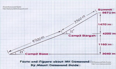
Damavand Basecamp to Summit
- Average ascend Time 10 hours.- Average climbing speed 800 m/h.
- Trail path distance 8000 meters.
- Altitude gain basecamp to summit 2630 m.
- Average ascent time 4 h
- Average climb speed 1175 meters/h
- Trail path distance between 2nd camp and 3rd camp 4700 m
- Height from 2nd camp and 3rd camp - 1160 m
- Direct distance between 2nd camp and 3rd camp 3182 m
- Avarage slope angle 21.8 deg
- Max slope angle 33.3 deg ( from 3807 m to 3861 m)
- Min slope angle 11.5 deg ( from 3095 m to 3115 m)
Camp 3 Bargah to Summit
- Average ascend time 6 h- Trail path distance between camp 3 and summit 3300 m
- Height from camp 3 to summit 1470 m
- Direct distance between camp 3 and summit 2687 m
- Avarage slope angle 31 deg
- Max slope angle 39 deg (from 4910 m t0 4973 m)
- Min slope angle 12.7 deg (from 5522 m to 5544 m)
Over All Measurements
From Basecamp to Summit- Average ascend time 10 h
- Average climb speed 800 meters/h
- Trail path distance between camp 2 Base and summit 8000 meters
- Direct distance between camp 2 Base and summit 5840 m
- Avarage slope angle 26.76 deg
- Max slope angle 39 deg (from 4910 m t0 4973 m)
- Min slope angle 11.5 deg (from 3095 m to 3115 m)
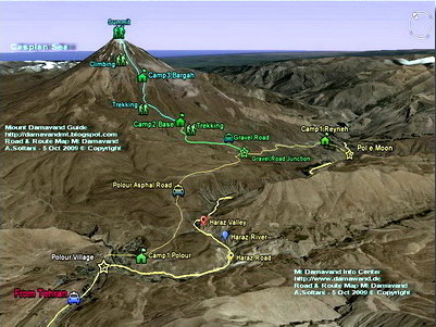
- Camp 1 Polour to Camp 2 Base distance 17.7 Km
( 11.3 Km asphalt road + 6.4 Km gravel road )
- Tehran (Serah TehranPars) to Camp 1 Polour distance 73 Km
- Tehran IKA Airport to Camp 1 Polour distance 133 Km
Because of its accessibility by car, distance between camp 1 and camp 2 base is excluded in some measurements.
Damavand Quick Facts
Farsi Name
Koh Damavand alternate Donbalvand, Dood koh ,Koh DamawandEnglish Name
Mount Damavand or Volcano Damavand, Damavand VolcanoAlternate Spell:
Mount Damawand, Damawand, Demavand, Demavend....
Damavand Location and Coordinate
Central Alborz Range Mountains Iran 80 Km North- East of TehranDamavand General Facts
Distance from Tehran drive by road: 80kmAttitude: 5670 meters, 18,600 feet, Visit Elevation.
Peak Coordinates: Lat: 35.954466°, Lon: 52.110020°
Best source of info: Mount Damavand Guide
Best Climbing Time: 10 June To 20 August
Best Climbing Side: South face
Quick Climbing Program: 2 or 3 days
Best Start point: Polour, a small village at the south side of the Damavand.
First Climbs: We believe there has been may unrecorded climbs in ancient years.
First Recorded Climbed: 1837 by W.T Thomson
Status: not active also see: Volcanic Activity of Damavand
Most Recent Eruption: None on record.
Nearest International Airport: MehrAbad or IKA Airport Teheran, Iran.
Damavand Facts & Statics for Hiking & Trekking Tour
Ranking
Highest peak in Persian Plateau and the Middle East.Highest dormant volcano in Asia and the second highest volcano in North Hemisphere.
More Facts for Damavand Climbing South Route
Difficulty and Climbing Grade in SummerDifficulty: F, YDS class 2 (plus sulphur gas above 5400 m).
Route type: Basic mountaineering.
Difficulty: Moderate walk-up, easy descend.
Damavand South Route Major Campsites:
- Camp 1 Polour 2270 m.
- Camp 1 Reineh 2070 m.
- Camp 2 Base 3040 m.
- Camp 3 Bargah Sevom 4220 m.
- Camp 3 New Hut 4250 m.
Distance Between Damavand Campsites:
- Track Camp 2 Base to Camp3 Bargah: 4700 m.
- Track Camp 3 to Summit: 3300 m.
- Track Base Camp to Summit: 8000 meters.
Time and Speed for Damavand Hiking :
Base camp to Summit.
- Average ascend Time 10 hours.
- Average climb speed 800 m/h.
Vertical Gain Damavand:
Camp 2 Base to Camp3: 1160 m.
Camp 3 to Summit: 1470 m.
Total Base Camp to Summit: 2630 m.
Status Damavand Volcano: not active. See Volcanic Activity.
Most Recent Eruption: None on record.
Most Experienced Guides: Damavand Guides.
Most Updated Weblog: Mount Damavand Guide, Contact Serppa[at]gmail[dot]com.
Most Informative Website: Damavand Info, Contact Solard[at]gmail[dot]com.
Damavand First Climbs: We believe there has been may unrecorded climbs in ancient years.
First Recorded Climb: 1837 by W.T Thomson.
Damavand Location: Central Alborz Mountain Range Iran, 80 Km North East of Tehran.
Nearest International Airport: IKA Airport (or Mehrabad) Teheran, Iran.
Damavand Other Names and Spellings
English: Mount or Volcano Damavand, Damawand, Demavand, Demavend, Donbavand, Damāvand. Visit also Damavand Forum.Farsi/Persian: Koh e Damavand alternate Dood koh, Koh Damawand, Qolleh Damāvand.
Donbalvand, Dive Sepid, Koh e Ghaf.
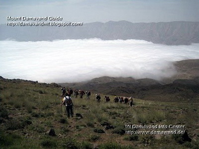
Damavand
Photo by A. Soltani
Damavand
Damavand Mountain, Iran 5670 meters, 18,600 feet, is the most prominent peak in Iran. It is The highest volcano in Asia and the 3rd highest volcano in the volcanic seven summits (V7S). Trekking Damavand, this respectable giant mountain is a life time memory. The experience of trekking to this summit is very rewarding. Before attempting Trekking Damavand Iran, you should know all the necessary information for hiking this mountain.Damavand Acclimatization
Ascend to Damavand Iran in summer is not technically difficult but physically it is a hard trek. The main challenge of the climb is acclimatization because the air gets thinner with less oxygen as you go higher. To raise the chance of success and lower the risk of AMS and to enjoy a safe hike to the peak it is essential to get accustomed to this new environment.
Damavand Accommodation
For a safe trek to any summit is essential to find the proper accommodation and use the safest campsites in the area. If you intend to attempt Damavand summit either from the classic south route or the west trail, the following campsites are the best places for accommodation and settlement. Camp 1 Polour Resort in Polour Village as the first camp and the best starting point and Camp 3 Bargah New Hut as the high camp.
Damavand Climate
In general terms Mount Damavand has different Climates and seasons for hiking & trekking, climbing and ski touring. Mid-June to mid-September the weather is ideal for summer trekking, November to May the conditions becoming difficult for winter climbing and December to April suitable for ski mountaineering, snowboarding and snowshoeing.
Damavand Difficulty
Damavand is well-known for its mild slops. Hiking Damavand, this 18,600 feet giant volcano is technically easy but physically a tough challenge and requires a good physical fitness. The main challenge of ascend is acclimatization and the weather. Trekking in summer is comparable to Mount Kilimanjaro in Tanzania and Mount Everest Base Camp in terms of Difficulty. But winter climbing is a quite different story and may be compared to a 7000 m peak or more.
Damavand Facts
Damavand height is 5671m. It is the highest peak in the Middle East and the highest volcano in Asia and the second highest in northern hemisphere. Ascend to this peak in summer is technically moderate but physically a tough challenge. In general terms you climb total 8 km trail distance in 10 hours. That is 4700 meters from c2 to c3 in about 4 hours on the first trekking day and 3300 meters from c3 to the top in about 6 hours on the summit day. Gaining 2630 meters height from base to the peak in just 2-4 days. More detail in Facts and Statics.
Damavand Google Earth
Before actually starting your program to Damawand Mountain in Iran it is a good idea to have a virtual trip by Google Earth and get an impression about the campsites, the best route and the trails, shelters, safe havens and mountain resorts in the area. Install Google Earth software on your computer or your smart phone and follow the tracks.
Damavand GPS
If you want to explore Mount Damawand near Tehran by yourself, GPS Track is the most useful guidance for your expedition. It displays the best possible trail and the suggested footprint. GPS track file is the most helpful tool for trekking Volcano Damavand in Iran. You can upload these files to your handheld gps device to show you the precise location and direction.
Damavand Guide
Recommended pages for trekking and ski touring to Damavand Iran.Best source of information for trekking and ski touring to Mount Damavand.
For more info visit: Damavand Camp.
This post is very useful: Damavand Weather.
Damavand Location
Damawand Mountain is located in Larijan district in Mazandaran Province in northern Iran. It is standing on the south coast of the Caspian Sea in the middle of the Alborz Mountains about 80 Km North-East of the capital city Tehran. The coordinates and the GPS landmark of Mount Damavand, Iran south peak is: Latitude 35-57-19 N, Longitude 52-06-37 E.
Damavand Maps
In our websites you can find and download some useful road and route Maps for trekking Mt. Damavand Iran. These helpful maps show you the entire track and footstep details and show you how to start from Tehran and go to the campsites and reach the Damawand peak.
Damavand Timing
Best Timing to trek Damawand Mountain is mid-June to mid-September. In this season the south route ridge and the climbing footpath is usually free of snow. The weather is generally mild in summer and the access by 4WD vehicles to the base camp is possible. Remember in this period the Damavand campsites are crowded in Iranian weekends (Thursday and Friday). The beginners are strongly advised to attempt the mountain only in this climbing season.
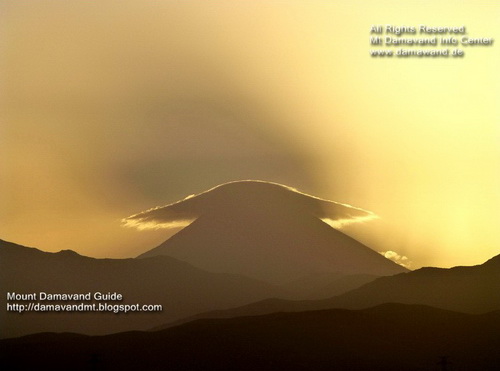
Damavand Cap Cloud During Sunrise
View from Sorkheh-Hesar Park Tehran
Photo Ardeshir Soltani
Damavand
Damavand is a well-shaped volcano. Due to its conical shape is possible to climb it from many sides. There are about 16 known Routes to the peak with different difficulties, some very difficult and require rock climbing techniques. But 4 climbing paths are well-known because there are good shelters or suitable campsites midway.
On the south route of Damavand Mountain there is a frozen Waterfall (or icefall) called Abshar Yakhi. This icyfall it is about 12 m tall and situated the elevation of 5100 masl, it is the highest fall in Iran and the Middle East. There is also a small glacier in the volcano crater which is accumulated with snow and ice, usually frozen during the year. Due to freezing temperature at the summit there is little chance to see water, only in a hot summer it could melt and form a small pool.
Damavand Climbing Routes
Damavand has sixteen known climbing routes with different difficulties.Damavand Popular Route
The most popular one for trekking is the south face which has very clear foot prints. The south trail has excellent mountain resorts at Polour Village 2200 masl and also a newly constructed midway campsite called Bargah Sevom New Hut at 4250 masl. Most mountaineers prefer to climb from the classic south route which is also the suggested climbing route for the beginners too. A reliable Mount Damavand Guide is highly recommended to increases the chance of success.
This side is the recommended for trekking tours. The starting point is Polour village and overnight at the major settlement at third campsite called Camp 3 Bargah Sevom or the New Hut at 4250 masl (13940 ft). This mountain resort was constructed in 2008 by Iranian Mountaineering & Sport Climbing Federation.This side has easy access from Tehran. The short distance from Tehran to the first camp at Polour Village make this approach the best route of Damawand Mountain. This is by far the best side and the ascent to the summit by this way is much safer.
Damavand Shortest Route
West route is the shortest side of Damawand Iran. The west route is famous for its sunset view. The starting point is Polour village and overnight at Simorgh refuge, a two floors refuge at 4200 masl (13,800 ft). The route type is basic mountaineering with moderate difficulty and climbing grade is walk-up, basic snow and cold but difficult descend.
Damavand Longest Route
North East route (Gazaneh trail) is the longest trail of Damavand Mountain. It takes two complete days to reach the summit. The starting point is Nandal village and overnight at Takht-e Fereydoun shelter at 4500 masl ( 14,760 ft). The route type is typical mountaineering with long trail difficulty and hard ascend with cold wind and long descend.
Damavand Difficult Route
North face of Damavand is the most Difficult route of the mountain for climbing. It has two shelter called 4000 and 5000. The route difficulty is scrambling mountaineering, steep, hard ascend, depending on season, cold and windy, snow & ice, difficult descend.
Mount Damavand Iran Facts And Info
FAQs Damavand Facts & Info
FAQs (questions and answers) about Mount Damavand Facts, statics & InfoYou can access a more comprehensive FAQ about Mount Damavand, Iran on our forum, the Damavand Forum. Please note that all information is provided in the English language.
- Q: What kind of volcano is Damavand? A: Damavand is a dormant stratovolcano.
- Q: How tall is Mount Damavand? A: Mt. Damavand's elevation is approximately 5,670 meters (18,600 feet) above sea level. It is the highest peak in Iran. See also my Damavand Height GPS Measurment.
- Q: Is Damavand Volcano an active volcano? A: Damavand Volcano is considered a dormant volcano, meaning it hasn't erupted in recorded history but still has the potential for future eruptions.
- Q: Where is Damavand Mountain located? A: Mt Damavand is situated in the northern part of Iran, about 80 kilometers (50 miles) drive from Tehran, the capital city. It is located in the central Alborz mountain range.
- Q: What is the significance of Mt. Damavand in Iranian culture? A: Mount Damavand in Iran holds a prominent place in Iranian mythology, literature, and culture, often symbolizing strength and beauty.
- Q: Can Mt Damavand be seen from Tehran? A: On clear days, Mount Damavand Iran is visible from Tehran and adds to the city's scenic beauty.
- Q: How difficult is it to climb Damavand? A: Climbing Damavand Mountain can be challenging, and it is considered a technically moderate ascent, suitable for experienced hikers and mountaineers. Visit Damavand Difficulty.
- Q: What is the best time to climb Mount Damavand Iran? A: The best time to climb Mount Damawand is during the summer months, from late June to early September when weather conditions are more favorable.
- Q: Are there any hazards associated with climbing Mount Damawand? A: Yes, climbers should be aware of potential hazards such as altitude sickness, extreme weather, and potential rock falls. Visit Damavand Safety Considerations.
- Q: Are there any accommodation options on Damavand? A: Yes, there are mountain huts and shelters at various altitudes on the mountain, providing basic accommodation for climbers. Read more in Damavand Camp.
- Q: Can I reach the summit of Damavand Mountain without a guide? A: While it is possible for experienced mountaineers, having a local guide is highly recommended for safety and to navigate the terrain effectively. Find the best reliable Damavand Mountain Guides in Iran HERE.
- Q: How much time does it usually take to ascend Damavand Iran? A: The duration of the climb varies depending on factors such as the chosen route, weather conditions, season, physical fitness of the climbers, and your acclimatization. On average, it takes 2 to 5 days to reach the summit and descend. Visit How to Climb Damavand and Damavand Itinerary.
- Q: Is there any wildlife on Mt. Damavand in Iran? A: Yes, Damavand is home to various wildlife species, including the Persian ibex and different bird species.
- Q: Are there any religious or spiritual associations with Mt Damavand? A: Damavand Mountain is mentioned in Persian mythology and is associated with Zoroastrianism and other ancient beliefs. Find more in Damavand Mythology.
- Q: Are there any glaciers on Mount Damavand? A: Yes, there are several glaciers on Damavand Iran, although they have been retreating over the years due to climate change. Read more in Mount Damavand Glaciers.
- Q: Can I see the Caspian Sea from Damavand's summit? A: On exceptionally clear days, it is possible to see the Caspian Sea from the summit of Mt. Damavand in Iran.
- Q: Are there any ski resorts on Damavand Mountain? A: Yes, there are ski resorts for Damavand ski mountaineering and Damavand ski touring on the mountain itself, some nearby areas such as Mount Doberar Ski Resort near Lasem village also offer skiing opportunities during the winter season.
- Q: Is there any folklore associated with Damavand? A: Yes, Mount Damavand Iran appears in various Persian folktales and is often considered the home of mythical creatures.
- Q: Can I visit Damavand Mountain as a day trip from Tehran? A: Given the distance and the time required to climb, visiting Mount Damavand as a day trip from Tehran is feasible; it requires proper planning and preparation.
- Q: What is the average temperature on Mount Damavand? A: The average temperature on Mount Damavand varies with altitude but generally ranges from -10°C to 5°C (14°F to 41°F) during the climbing season. Visit also Damavand Weather Forecast.
