Damavand GPS Track
Helpful info for Ascending Mount Damavand.
- Related Topics
- Maps
- How To Climb
GPS Track File for Climbing Mount Damavand
By Garmin Oregon 550 Navigator(To save battery, some tracks are recorded when descending!)
GPS Track File is the most helpful tool for climbing Damavand Mountain, Iran. If you intend to explore the mountain, you can find some useful GPS tracks for your expedition to show you the best possible trails and the recommended footprints. See also Damawand GPS Tracks FAQ.
Looking for more information visit Mount Damavand Facts.
These tracks can be uploaded to your handheld gps device to determine your precise location, or you can use GoogleEarth software on your pc or smart phone to view the tracks. It is a very helpful aid to find your way specially in case of bad weather and foggy condition, it could save your time, energy and also save your life. Guide Mount Damavand Iran.
The best shortcut and the most suggested route to asced the Damavand from the south route is Tehran to Camp1 Polour Hut, ie:
Camp1 Polour> Camp2 Base> Camp3 Bargah Sevom New Hut> Summit.
And return the same way back.
Download GPS Tracks in GPX Format
Camp1 to Camp2
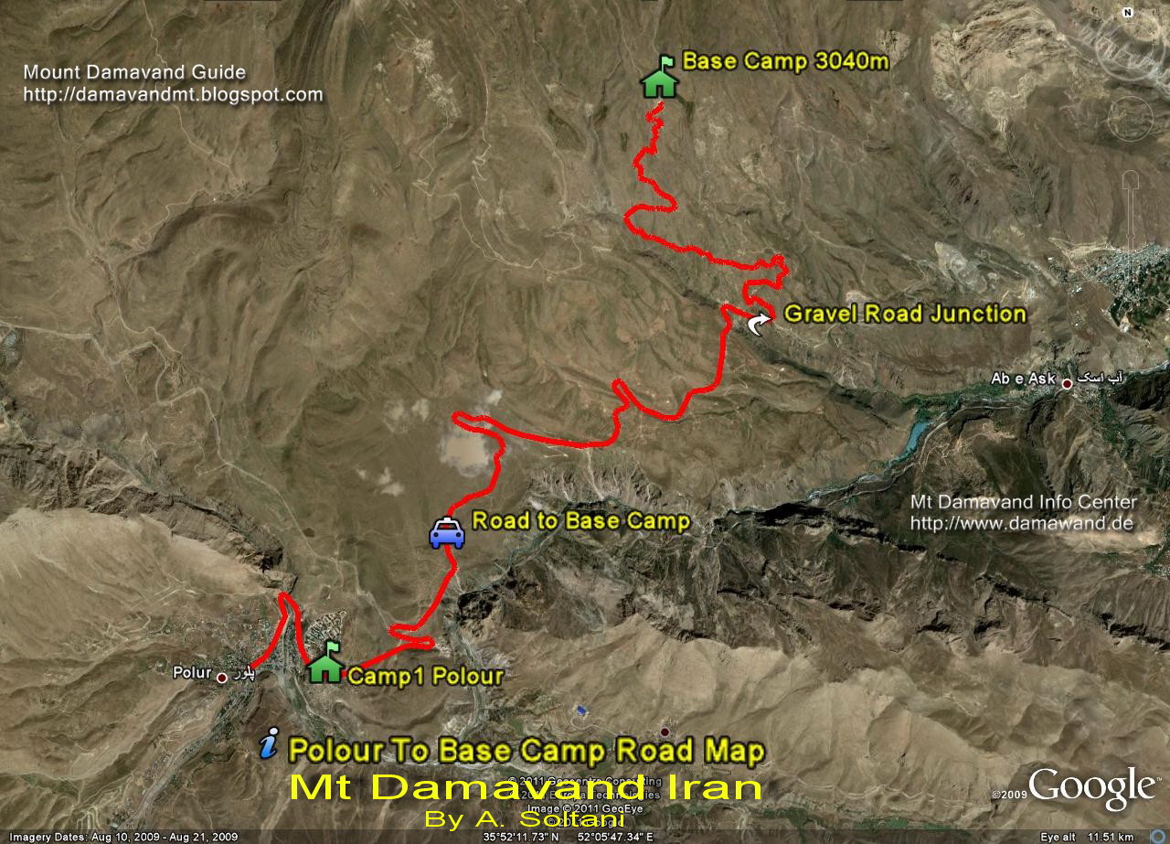
GPS Tracks and Route Map Camp1 Polour to Camp2 BaseGPS Track File: Download
Full Size Image Route Map: Download
Gravel Road, by car in summer or walk in winter.
Camp1 Polour
It is the best place for your acclimatization and accommodation, this new complex campsite with a hostel is made by Iranian Mount Federation.
Read more info about Camp1 Polour
Gravel Road Junction
It is the winter staring point to the camp2 base when it is not posible to use the gravel road by car due to heavy snow and icy condition. When you want to go to Base Camp, either from Camp1 Polour or Camp1 Reyneh you will come to this junction anyway. Climb Mount Damavand Iran.
Camp2 Base
Farsi Name Gosfand Sara, there is a shelter, a mosque and a sheepfold in this area.
Camp2 Base is the summer starting point and it is not a suitable for use in summer, it is too noisy, crowded and dirty, for acclimatization you are recommended to use camp1 Polour and Camp3 New Hut instead. Trekking Mount Damavand Iran.
Read more info on Camp2 Base

Download and View The Original Size Image
Damavand Camp1 to Camp2 GPS Track and Route Map
Drive the Gravel Road by car in summer or walk and on ski in winter
By Ardeshir Soltani, Mount Damavand Guide
Camp2 to Camp3
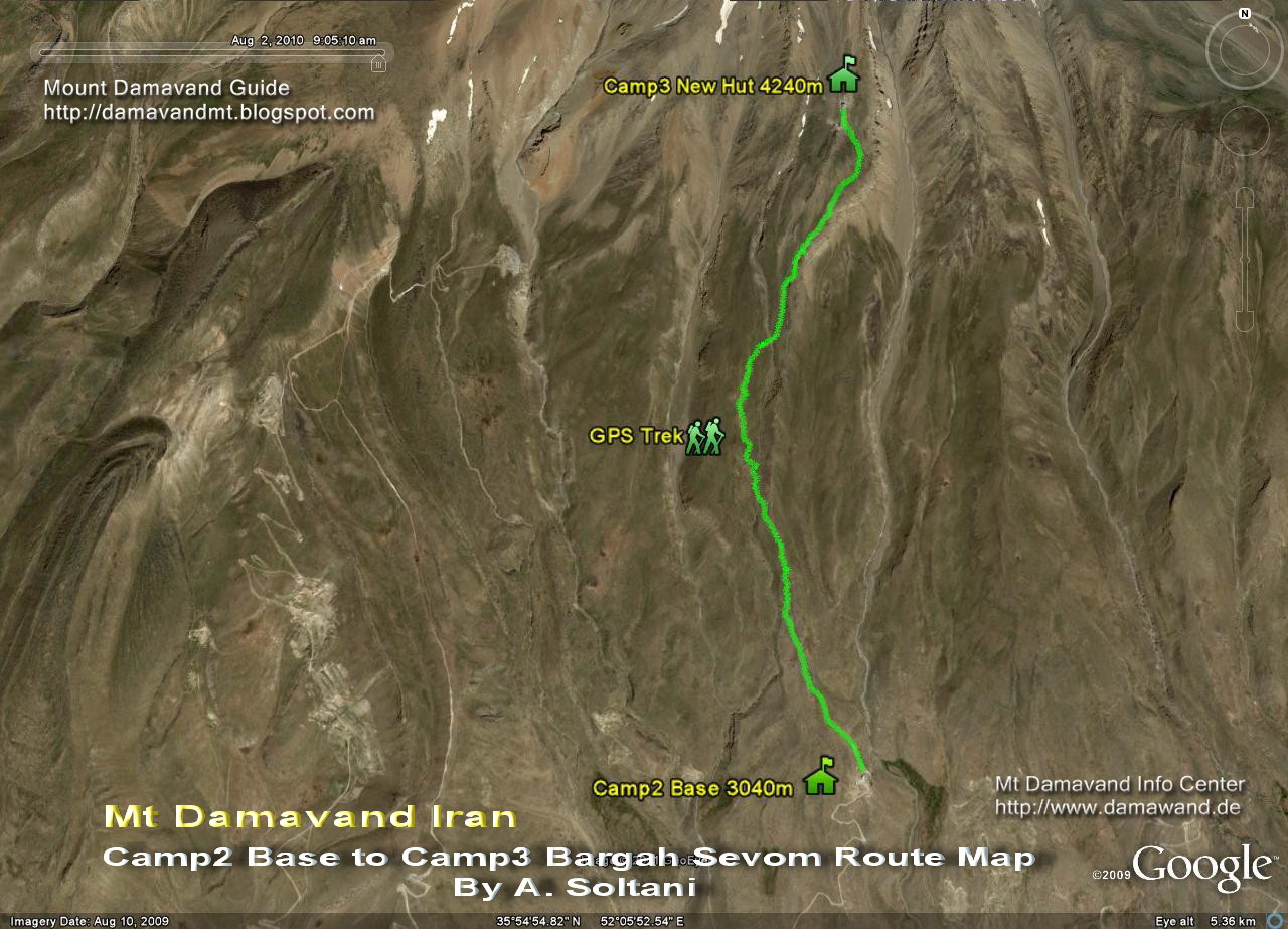
GPS Tracks and Route Map Camp2 Base to Camp3 Bargah SevomTrack Camp2 Base to Camp3 Bargah Sevom Old Shelter or the New Hut.
GPS Track File: Download
Full Size Image Route Map: Download
Camp3 Bargah Sevom Old Shelter
This Shelter is crowded in summer specially in Iranian weekends, Thursdays and Fridays and holidays, it is not suitable for use, you may either use a tent or book and use the Camp3 New Hut beds for better comfort and privacy.
Read more info on Camp3 Old Shelter
Camp3 New Hut
This New Hut is made near the old shelter/refuge, it is one of the highest huts in the word and the best resting place in the area.
Read more info on Camp3 New Hut.

Download and View The Original Size Image
Damavand Camp2 to Camp3 GPS Track and Route Map
By A. Soltani
Trekking Tour Mount Damavand
Camp3 to Summit
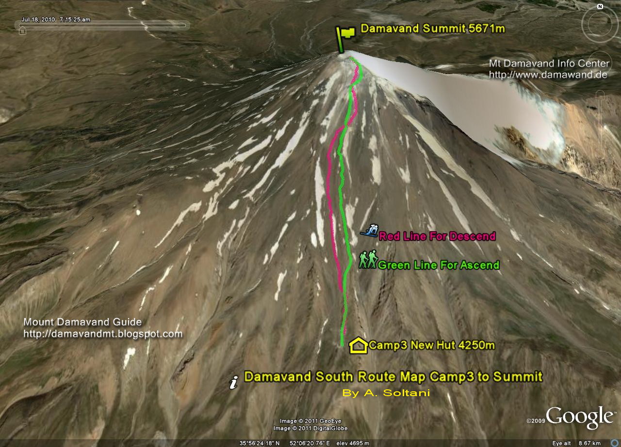
GPS Tracks and Route Map Camp3 Bargah Sevom to Mt Damavand SummitFrom Old Shelter/Refuge or the New Hut to the peak.
GPS Track File Camp3 to Summit Ascend Track : Download
GPS Track File Summit to Camp3 Descend Track: Download
Full Size Image Route Map Camp3 to Summit: Download

Download and View The Original Size Image
Damavand Camp3 Bargah Sevom to the Summit Route Map
Green line for ascend from Old Shelter or New Hut to the top
Red line for descend or ski from Mt Damavand peak to Camp3
By A. Soltani
Damavand Mountain Ski Touring
IKA Airport to Camp1 Polour
GPS Tracks and Route Map IKA Airport Tehran to Camp1 Polour ResortGPS Track File IKA Airport to Camp1 Polour: Download
Full Size Image Route Map IKA Airport to Camp1 Polour: Download
How to go to Mt Damavand
Tehran> Haraz Road> Polour Village> Camp1 Polour Resort
GPS Track
A GPS track is continuous tracking data file which is recorded by a GPS receiver or a GPS tracker at regular intervals by using the Global Positioning System satellites to assist and show you the exact location of a route or a track, these information include altitude, coordinate, latitude, longitude and speed, it could be in various formats such as CSV, KML or GPX. The recorded data can be stored within a gps device or a pc to allows the precise location of a route/person to be displayed against a map backdrop when analysing the track later, by using GPS tracking software. Damavand Mountain Mythology.

Download and View The Original Size Image
IKA Airport to Damawand Camp1 Polour Map
By A. Soltani
Damavand Volcano, Iran
More in MDIC
Damavand GPS track file. GPS tracks are helpful tool for climbing Iran mountains. Useful GPS tracks and landmarks for mountain expedition. Mt Damavand Iran Weather Forecast. GPS track shows the best routes and trails and the recommended footprints. GPS landmarks for mountainerring and outdoor activities tours. Tehran climbing, hiking & trekking expedition tours 2015. Download Damawand GPS track and landmarks, route and trail maps. Download GoogleEarth satellite image for Ski and snowboard tours. Demavand Map. Low budget tour to damavend iran.
Damavand GPS Tracks MDIC22MAY14UL