Damavand Danger Zone
Helpful info for Climbing Mount Damawand South Route Iran.
- Related Topics
- Maps
- GPS Landmarks
- GPS Tracks
Mount Damawand Risky Zone
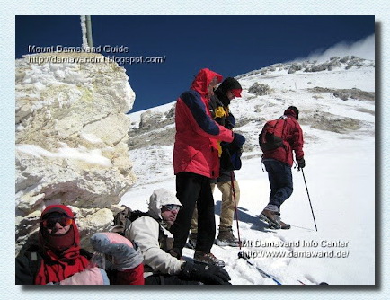
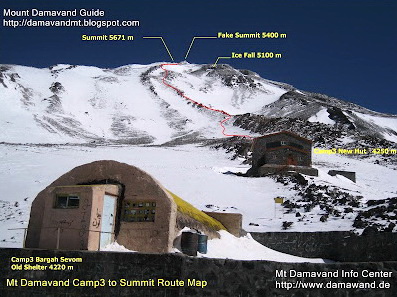
There is an area on the southern route of the Mount Damavand called the Danger Zone. It is the most risky part of the mountain during bad weather, poor visibility, snow, fog and cloudy condition. Danger Zone is located between the fake summit 5400m and the real peak 5670m.It has a mild climbing slope, without rocks and signs, it looks like a desert with only a few guideposts which you can not find them in foggy and cloudy condition. In a good visibility it is not a difficult part of the mountain.
It is similar to the Bermuda Triangle!. But there is no mysterious or supernatural events there, just mountaineers are not able to find the right trail in this part when they return back from the summit in bad visibility. It looks like a one way road! you can ascend it easily, but you can not find your way back to Camp3.
The main cause of disaster in the area is bad weather and poor visibility. Even in conditions that make it difficult to see clearly without any particular equipment it is possible to climb to the top, but it isimpossile to find any sign, footprints and your way back to descend to the lower camps and you may finish with a bitter end.

Fake Summit Damavand
Begining of Danger Zone
Warning
In bad weather:- Do not go upper than fake summit 5400m.
- A reliable GPS receiver is essential.
- An experienced Mt Damawand Guide is helpful.
GPS Track
Useful GPS Track file for Damawand Danger Zone:Download GPS Track File
GPS Landmark
The danger zone stars from this point upto the summit, it is also the sulphuric area of the volcano.Fake Summit
Altitude 5400 mLatitude 35-57-05 N
Longitude 52-06-37 E
Alternate Names for Fake Summit
Mosalasi, Baam e Jonobi, Sang e Pes-tan, Dood koh.Victims of Damawand Danger Zone in recent years
Spring 2009
After their climb to the peak and on their way back, four climbers from Bandar Abas Province Iran, lost their way towards the west ridge, three of them died and only thier leader survived. The Victims:- Torabi Abdul Hamid
- Memari Farkhoundeh
- Keshmiri Sajedeh
Summer 2008
Two climbers from Hamedan Province Iran after their successful climb, lost their way to east ridge, near Yakhar Glacers and died there.Spring 2002
Jalal Froozan Rabooki from Tehran, the most famous Iranian climber, lost his way back and had bitter end, his body was found 6 months later in Yakhar Glacers.Visit also Damavand Weather Forcast.

Route Map Damawand Iran
Fake summit is visible at the top
Everything About Mount Damavand: Iran’s Highest Peak at a Glance
Everything About Mount Damavand offers a concise yet comprehensive overview of Iran’s highest peak. Towering at 5,671 meters, this majestic mountain is not only a popular climbing destination but also a significant figure in Persian culture and history. This guide gives a quick glance at its key features, including the mountain’s location in the Alborz range, its volcanic nature, and its role in local mythology. Whether you’re planning to climb or simply admire its beauty, this resource covers the most important aspects of Mount Damavand in a compact format.
Mount Damavand Climbing Campsite
Damavand Camp goes by multiple names, such as Damavand Base Camp, Damavand Camp II, and the second camp on the mountain. Locals refer to it as Goosfand-Sara (گوسفند سرا ), meaning "sheepfold," or the Saheb al-Zaman Mosque (مسجد صاحب الزمان ) campsite. This key stop offers basic amenities for climbers and trekkers, allowing them to rest and prepare before ascending Mount Damavand.
It is the most accessible and well-known starting point for expeditions on Mount Damavand. The camp provides necessary facilities like a mountain refuge, the Saheb al-Zaman Mosque, and a sheepfold. Perched at 3,040 meters and located at Latitude 35.9020° and Longitude 52.1094°, it serves as the main base camp for those climbing the south route, especially in the summer. This is the primary spot for rest and preparation before the ascent begins.
Trekking Tour on Damavand’s South Route
The trekking tour on Damavand’s South Route is one of the most popular options for adventurers looking to reach the summit. This route offers moderate difficulty, making it suitable for both novice trekkers and seasoned climbers eager to conquer Iran's highest peak. The guided tour packages include everything from essential equipment to comfortable accommodations, ensuring a smooth and rewarding experience on your way to the top of Mount Damavand. As you ascend, you’ll be treated to breathtaking views and unique geological formations, creating an unforgettable journey filled with excitement and natural beauty.
Best Damavand Climbing Experience with Local Guides
The Best Mount Damavand Experience with Certified Guides. To truly enjoy Mount Damavand, having certified guides is essential. Whether you're trekking, climbing, or skiing, their professional leadership ensures that you have a top-quality experience, free from worry. Mount Damavand's certified climbing guides offer a deep understanding of the mountain's unique features and ensure that your adventure is as rewarding as it is safe. With local expertise and international standards of safety, you’ll experience the highest quality climbing, trekking, and skiing available.