Damavand Hiking Routes and Campsites
Best Source of Info for Damavand Climbing Routes, Hiking Trails, and Trekking Footpaths
- Related Topics
- Damavand GPS Tracks, Damavand Maps
Mount Damavand Trekking Routes and Campsites
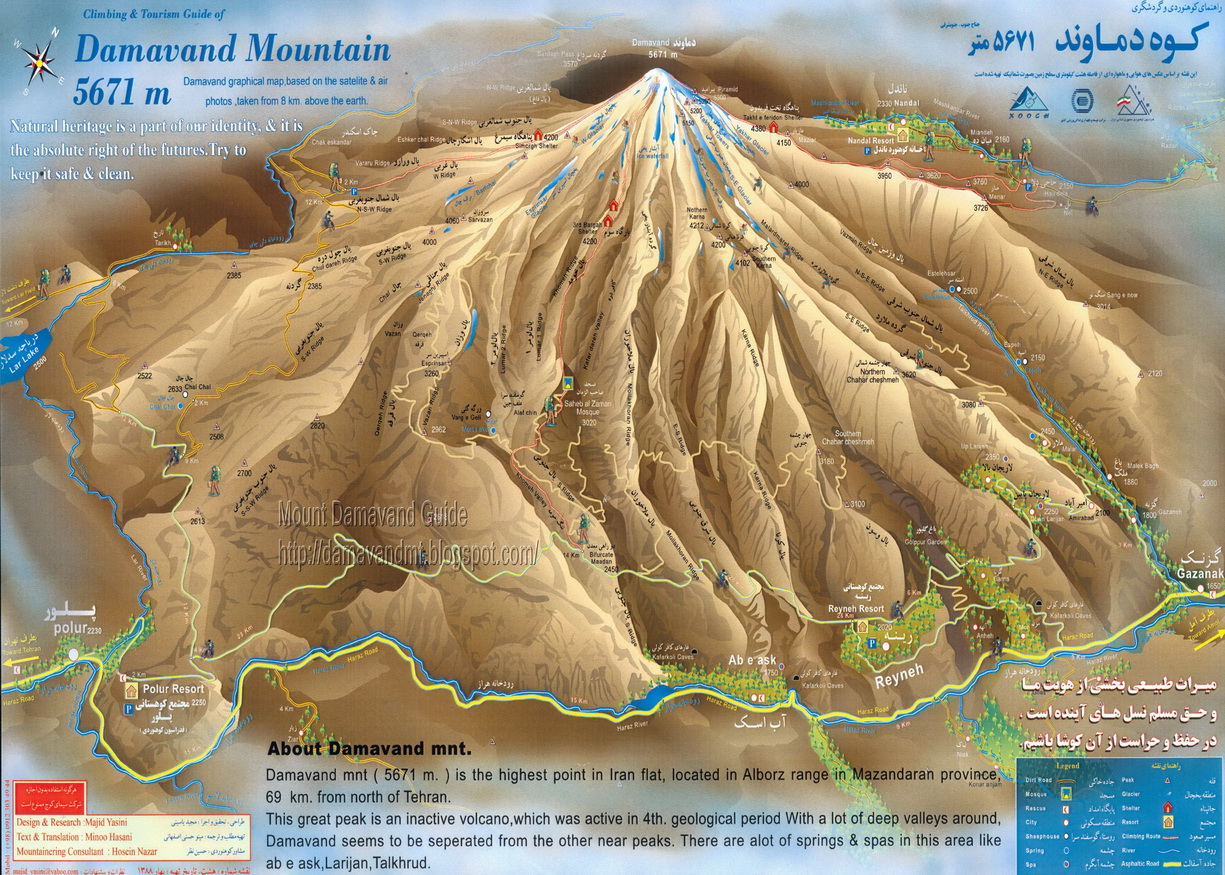
Routes and Trails to Damavand Peak: Damavand Mountain in Iran offers sixteen different climbing paths to reach its summit. Among these, four trekking routes stand out for their popularity among hikers and climbers: the South, West, North, and North-East routes. Each of these routes features a campsite, shelter or refuge located at approx. 4000 meters above sea level. Additionally, the North face boasts an additional shelter at around 4,620 meters. The Damavand classic south hiking trail is particularly favored, drawing many climbers due to its well-equipped Bargah Sevom new mountain resort situated at 4250 meters. As a result, most mountaineers opt to ascend from the south face hiking paths of the mountain.
Mount Damavand west trekking route and Simorgh Shelter
1- Damavand West Route and Campsite
The Mount Damavand west trekking route, is classified as basic mountaineering, offering a moderate level of difficulty with a climb that is relatively straightforward. Climbers can expect a moderate walk-up hiking trail experience, encountering basic snow and cold conditions along the hiking way. However, the descent on this trekking path is notably challenging, requiring careful navigation and skill.Mount Damavand West Front Hiking Trail Camp-Site:
Mount Damavand Polour Village Hut:
Coordinates: Lat: 35.8465°, Long: 52.0605°, Alt: 2,270 m. Mount Damavand Simorgh Shelter:
Coordinates: Lat: 35.9564°, Long: 52.0825°, Alti: 4,200 m.
Find Details about Damavand West Route and Campsite Show/Hide


Simorgh Shelter Damavand West Front Hiking Trail Campsite
lat: 35.9564° – lon: 52.0825° – alt 4,200 m
Mount Damavand Hiking Trekking and Climbing Routes & Camps
2- Damavand Northeast Route & Camps
The Damavand North-East hiking trail is a challenging mountaineering path, known for its tough and lengthy ascent. Climbers face cold and windy conditions along the way, making the journey even more difficult. The climbing footpaths requires a great deal of endurance and determination as climbers navigate through the rugged terrain and harsh weather.
Mount Damavand North-East Hiking Route CampSite - Nandal Trail
At approximately 4,380 meters above sea level, climbers will find the Takht-e Fereydoun shelter. This refuge provides a crucial resting spot for climbers to recuperate during their arduous climb. Situated strategically along the mountain trekking route, Takht e Fereydoun offers shelter from the elements, allowing climbers to take a break and regain their strength before continuing their ascent towards the summit of Damavand Mountain.
Mount Damavand NorthEast Route Hiking Trail Campsite
Damavand Nandal Local House:
Coordinates: Lat: 36.0303°, Long: 52.1740°, Alt: 2,350 m.
Damavand Takht-e Feridon Refuge:
Coordinates: Lat: 35.9665°, Long: 52.1341°, Alt: 4,380 m.
Find Details about Damavand Northeast Route and Campsite Show/Hide


Takht-e Fereydoun Shelter
Damavand Northeast Climbing Route
lat: 35.9665°, lon: 52.1341°, alt: 4,380 m
3- Damavand South Route & Camps
The Damavand south trekking route stands out as one of the most accessible paths to the summit, especially for those traveling from Tehran or the northern regions of Iran. Its proximity to the main Haraz road from Tehran makes it a convenient choice for climbers. Not only is it easily reachable, but it's also considered the easiest mountain hiking trail and most favorable side of the Damavand. The ascent to the peak of Mount Damavand via this hiking path is shorter compared to others, offering a relatively straightforward journey for climbers.It's important to note that starting the climb during the night from the 3rd camp and hiking through the night to reach the summit around sunrise is not recommended, see also Top Mistakes When Climbing Mount Damavand. This approach can lead to increased exhaustion and poses a higher risk of altitude sickness (AMS). Additionally, many climbers who summit from other faces of the mountain andother mountain hiking footpaths , such as the West, North East, or North, prefer to descend via the South face trekking route due to its well-maintained footpaths and easier descent.
Discover the best camping spots along the Mount Damavand south route footpaths for your outdoor adventure. Start your journey at Polour Village Damavand campsite, (or if you coming from the north of Iran head to Rineh Town Damavand camping place).
Drive by car higher, find shelter at Damavand summer base camp also called Gosfandsara Shelter. For a higher vantage point, stay at Bargah Sevom Old Damavand Shelter or reach Damavand Bargah Sevom Hut. Experience the beauty of Damavand's south route mountain trails with these serene camping sites, offering peace and stunning views amidst nature's splendor.
Damavand Camps in South Trekking Route and Hiking Trail:
Damavand Polour Village Campsite:
Coordinates: Lat: 35.8465°, Long: 52.0605°, Alt:: 2,270 m.
Damavand Rineh Town Campsite:
Coordinates: Lat: 35.8816°, Long: 52.1661°, Alt:: 2,050 m.
Damavand Gosfandsara Shelter:
Coordinates: Lat: 35.9020°, Long: 52.1094°, Alt:: 3,025 m.
Damavand Bargah-Sevom Shelter:
Coordinates: Lat: 35.9305°, Long: 52.1085°, Alt:: 4,210 m.
Damavand Bargah-Sevom Hut:
Coordinates: Lat: 35.9316°, Long: 52.1093°, Alt:: 4,245 m.

View the Original Size
Mt. Damavand south trekking route, hiking trail and footpath
By A. Soltani, Mount Damavand Guide
4- Damavand North Face Route & Camps
The ascent of Mount Damavand's North face climbing route is widely acknowledged as the most challenging mountaineering route up the mountain. It demands a higher level of mountaineering skill and experience due to its steep and rugged terrain. Climbers must navigate through cold, windy conditions, often encountering snow and ice, which further add to the difficulty. Descending along this route poses its own challenges, contributing to the overall toughness of the journey.
Mount Damavand's North face climbing route and Campsites
Mount Damavand North Route & Campsites
During the climb on the Damavand north trekking trail, climbers will find two shelters positioned strategically along the trekking route: These shelters are called Damavand 4000-Shelter and Damavand 5000-Shelter, located at approximately 4000 and 4,620 meters respectively. These shelters serve as crucial resting spots where climbers can catch their breath and regroup. Despite the challenges, tackling this hiking path offers adventurers the opportunity to test their limits and experience the thrill of conquering one of Iran's most imposing mountains.
Mount Damavand North Face Mountaineering Route Campsites
Nandal Local House:
Coordinates: Lat: 36.0303°, Long: 52.1740°, Alt:: 2,350 masl.
Damavand 4000-Shelter:
Coordinates: Lat: 35.9782°, Long: 52.1112°, Alt:: 3,996 masl.
Damavand 5000-Refuge:
Coordinates: Lat: 35.9681°, Long: 52.1147°, Alt:: 4,624 masl.
Find Details about Damavand Northt Route and Campsites Show/Hide

")


Mount Damavand north route climbing route and Campsites
Damavand 5000-Shelter

More in MDIC
This page is the recommended page you might like for more data about Mount Damavand Info, Facts & Statics. Damavand climbing routes and trails. Mount Damavand Trekking Tour Program. Route and trail map for hike, trek and climb to highest peak of Iran. Mount Damavand Iran Ski Tour. Mountain tour operator based in Tehran. Skitouring in major Iranski resorts. Holiday package tours for Persia cultural and historical sites. Multi-day backpacking trekking trips. Iran sightseeing outdoor tour photos. Iran Outdoor Activity foto. Damawand Map. Low budget tour to demavand iran. Demawand Trekking Maps, Route and Trail Map, Summit Track.
Damavand Climbing Routes 24DIC0322A