Damavand GPS Waypoints
- Related Topics
- GPS Tracks
- GoogleEarth
Damavand South Route GPS Landmarks
The latest GPS Landmark for your travel to Damavand Mountain Iran (update 14 July 2009). It is a very useful guide specially in case of bad weather and foggy condition, it may save your life.If you want to climb from the south route the safest,the best shortcut and the recommended way is to stars from Camp1 Polour Resort:
Tehran> Camp1 Polour> Camp 2 Base> Camp3 Bargah Sevom New Hut> Summit
and return the same way back.
If you have enough time and energy left You may also visit the beautiful Icefall at 5100 M.

GPS Landmark Table South Route

Mount Damavand GPS Landmark
Camp3 Bargah Sevom to Summit Route Map
Damawand South Route GPS Waypoints
1- Terminal SharghTehran East Public Coach Station. A good place to find a car or a bus towards the mountain.
Altitude 1314 m
Latitude 35-43-25 N
Longitude 51-31-07 E
2- Camp 1 Polour
Polour Resort is the best starting point for Damavand South and West routes. A good place for your rest and accomodation. This Complex Campsite is made by Iranian Mount Federation.
Altitude 2270 m
Latitude 35-50-50 N
Longitude 52-03-36 E
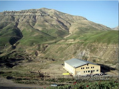
Mt Damawand Camp 1 - Polour Hut Altitude 2270 m
3- Poul Moon Junction (optional)
This landmark is also useful to visit Poul e Moon Caves.
(if you travel from Tehran to Damavand, you do not need this landmark ).
Altitude 1683 m
Latitude 35-53-25 N
Longitude 52-11-53 E
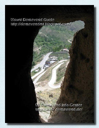
Demavand Poul e Moon Caves
4- Camp 1 Reyneh (optional)
Camp 1 Reineh is the olest campsite in the area. If you travel from Tehran to Damawand, you do not need this landmark.
Altitude 2078 m
Latitude 35-52-58 N
Longitude 52-09-58 E

Mt Damawand South Route Camp 1 - Reineh Altitude 2078 m
5- Gravel Road Junction1
The winter staring point and beginning of gravel road to basecamp. When it is imposible to use the gravel road by car due to snow and ice condition you have to start your ascend from this point. You may also start your trek from this point in summer season if you wish so.
When you travel either from Tehran, via Camp1 Polour Resort or from North of Iran, via Camp1 Reyneh town, you will come to this junction anyway.
Altitude 2458 m
Latitude 35-52-47 N
Longitude 52-07-16 E

Damavend Winter Climb from Junction Gravel Road
6- Gravel Road Junction2
Turn right here to goto damavand base camp.
Altitude 2778 m
Latitude 35-52-29 N
Longitude 52-06-13 E
7- Camp 2 Base
Camp 2 Base (Farsi Name Gosfand Sara), there is a shelter, a mosque and a sheepfold . During summer you can find water and some food here , but it is recommend to use your own. You may find mule and porter to carry your equipments to the next camp. Remember in other seasons base camp is a remote area. This camp is not suitable for use in summer, because it is too crowded and too dirty, for acclimatization you may use camp1 Polour or Camp3 Bargah Sevom instead. Read also warnings about BaseCamp.
Altitude 3040 m
Latitude 35-54-10 N
Longitude 52-06-34 E
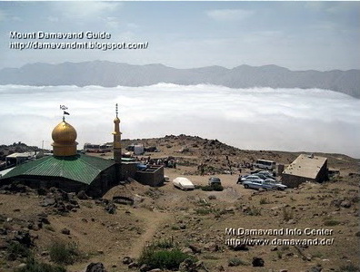
Mount Damavand Camp 2 - Base Altitude 3040 m
8- First Sign
Altitude 3172 m
Latitude 35-54-26 N
Longitude 52-06-23 E
9- Statues Ridge
Interesting place to take some photo of damavand volcanic statues.
Altitude 3247 m
Latitude 35-54-36 N
Longitude 52-06-19 E

Damawand Statues Ridge
Volcano Damavand
10- River 1
Seasonal river, it is usually dry in summer and coverd with snow in colder seasons.
(Second Sign - Cross the river to the left)
Altitude 3423 m
Latitude 35-54-53 N
Longitude 52-06-14 E
11- River 2
The same seasonal dry river.
( Third Sign - Cross the river to the right )
Altitude 3688 m
Latitude 35-55-18 N
Longitude 52-06-16 E

Mt Demavand Seasonal River 2 Sign
12- Sang e Du Shakh
The lar Lake is visible from this place.(Forth Sign)
Altitude 4055 m
Latitude 35-55-42 N
Longitude 52-06-31 E

Mt Damavend Sang e Du Shakh
13- Camp 3 Bargah Sevom
Camp3 Bargah Sevom is the last campsite on the south route, during summer season the shelter/refuge it is too crowded and in not suitable for use, it is recommended to book the new hut or bring and use your own tent for better comfort and privacy. You may find water, some food, rent tent and sleeping bag at this place in summer, but it is better to use your own equipments. A New Hut was constructed in 2009 in this area and is ready for use now.
Altitude 4220 m
Latitude 35-55-54 N
Longitude 52-06-30 E

Mt Damavand Camp 3 - Bargah Sevom Shelter 4220m
Camp 3 New Hut
The Camp3 New Hut is made at altitude 4250 m above sea level, just near the old shelter Bargah Sevom, it is one of the highest huts in the word and best resting place in the area.
Altitude 4250 m
Latitude 35 - 55 - 57 N
Longitude 52 - 06 - 32 E
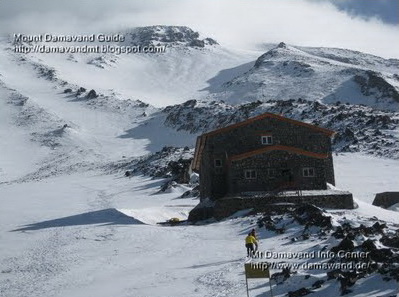
Mount Damawand Camp 3 New Hut
Mt Damavand Camp3 New Hut Sevom 4250m
14- Beginning of First Ridge
Altitude 4531 m
Latitude 35-56-18 N
Longitude 52-06-36 E
15- End of first Ridge
( change ridge to the left )
Altitude 4912 m
Latitude 35-56-39 N
Longitude 52-06-32 E
Icefall (optional)
icefall GPS landmark 31 Aug 2007
Altitude 5100M
Latitude 35-56-48 N
Longitude 52-06-40 E

Icefall at 5100m
16- Beginning of Sulphuric Area
Altitude 4947 m
Latitude 35-56-41 N
Longitude 52-06-30 E
17- Memorial Sign
(Late Mohsen Ghanbari)
Altitude 5080 m
Latitude 35-56-47 N
Longitude 52-06-32 E
18- Flat Area Sign Post
You have about half an hour hard work from here!
Altitude 5232 m
Latitude 35-56-56 N
Longitude 52-06-35 E
19- Fake Summit
Baam Jonobi, also called Sang e P-e-s-t-a-n
Get ready for sulphuric smell of the mountain!
Altitude 5400 m
Latitude 35-57-05 N
Longitude 52-06-37 E
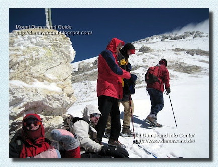
Mt Damawand Fake Summit
20- Last Sulphuric Hill
Altitude 5436 m
Latitude 35-57-08 N
Longitude 52-06-37 E
21- Beginning of Summit Rocks
Altitude 5562 m
Latitude 35-57-18 N
Longitude 52-06-41 E
22- Summit
South Face Summit. Congratulation you have done it! This is the peak, summit of Iran, and Middle East, top of the second highest volcano in Asia and peak of second highest volcano in the Northern hemisphere.
GPS landmark
Altitude 5621 m (GPS measurement by Ardeshir Soltani - 6 June 2006)
Altitude 5640 m (GPS measurement by Ardeshir Soltani - Friday 31 Aug 2007)
Latitude 35-57-19 N
Longitude 52-06-37 E

Demavand summit of Iran & Middle East
23- Highest Rock
Damavand South Face Summit is measured as 5,671 Meters, 18,605 feet in all old world records.
Altitude 5626 m (GPS measurement by Ardeshir Soltani - 6 June 2006)
Altitude 5645 m (GPS measurement by Ardeshir Soltani - 31 Aug 2007)
Altitude 5626 m (GPS measurement by Rafael Villegas - 23 July 2015)
Latitude 35-57-19 N
Longitude 52-06-36 E
You may also be intrested in these topics Google Earth and Maps.
Longitude
the angular distance of a place east or west of a standard meridian,
especially the Greenwich meridian.
Latitude
the angular distance of a place north or south of the equator.
(latitudes) regions with reference to their temperature and distance from the equator
Note:
Regarding the height of Mount Damavand, we believe hand held GPS unit results are not so accurate to refer to as a reliable reference and we think it worth to do some accurate measurements with some sophisticated equipments like advanced differential GPS.
(Last edited by Sherpa on 2 Sep 2007).

Mt Damavand Highest Rock about 5671m
Photo by Ali Najafi
Mount Damavand Revealed is the ultimate guide to understanding one of Iran’s most remarkable natural landmarks. At 5,671 meters, it is the tallest peak in the Middle East and a key figure in Persian culture. This guide provides detailed information on the mountain’s exact location, its ranking among global peaks, and its role in local myths and legends. Whether you’re a mountaineer or a lover of natural history, this comprehensive guide unveils all the essential facts about Mount Damavand.
Mount Damavand Alpine Camp
Damavand Camp, also known as Damavand Base Camp or Damavand Camp II, is locally referred to as Goosfand-Sara (گوسفند سرا ), meaning "sheepfold," or as the Saheb al-Zaman Mosque (مسجد صاحب الزمان ) campsite. It serves as an important base for climbers and hikers, providing a place to rest and prepare before attempting to summit Mount Damavand.
This is the most popular and easily accessible starting point for climbing expeditions on the mountain. The camp offers basic services, including a small mountain refuge, a mosque, and a sheepfold. Located at an elevation of 3,040 meters, with coordinates of Latitude 35.9020° and Longitude 52.1094°, it’s the key base for those taking the south route during the summer. Climbers use this site to rest and get ready for their climb.
Damavand Mountain Guided Adventure Tour
A guided adventure tour on Mount Damavand is the perfect way to explore one of Iran’s most iconic peaks. These tours are led by experienced local guides who know the mountain well, ensuring your safety while allowing you to fully enjoy the natural beauty of the area. With options for both trekking and climbing, these tours cater to various skill levels, making them perfect for anyone looking to challenge themselves and explore the great outdoors. Experience the excitement of ascending Damavand while learning about the region's unique ecology and culture from knowledgeable guides who share their expertise.
Certified International Damavand Ski Guide
Mount Damavand Ski Tour Guide: Unique Adventures in Winter. While Mount Damavand is known for its challenging climbs, it also attracts winter sports enthusiasts, particularly skiers. The mountain’s unique geographical features and snowy conditions make it an ideal destination for ski tours. Hiring a Mount Damavand ski tour guide ensures a safe and exhilarating adventure as you navigate the slopes of this iconic peak. These certified experts are well-versed in the best skiing routes, providing you with the necessary equipment, safety instructions, and guidance to make your experience both enjoyable and safe. Skiing down the pristine snow of Mount Damavand is an unforgettable experience that offers a different perspective of the mountain’s beauty, one that only a professional guide can unlock.