Best Source of Info for Damavand Climbing Routes, Hiking Trails, and Trekking Campsites
Mount Damavand Trekking Routes and Camps
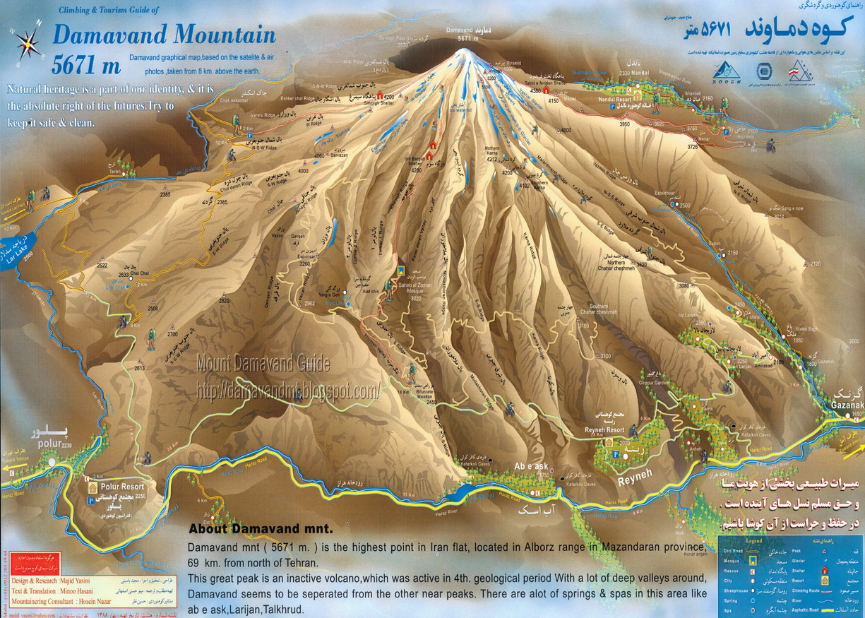
Mount Damavand in Iran offers sixteen different climbing paths to reach its summit. Among these, four trekking routes are particularly popular with hikers and climbers.
Damavand also boasts ten camps and shelters, providing essential amenities for hikers and mountaineers.
Damavand Trekking Routes
Routes and Trails to Damavand Peak: Damavand Mountain in Iran offers sixteen different climbing paths to reach its summit. Among these, four trekking routes stand out for their popularity among hikers and climbers: the South, West, North, and North-East routes. Each of these routes features a campsite, shelter or refuge located at approx. 4000 meters above sea level. Additionally, the North face boasts an additional shelter at around 4,620 meters. The
Damavand classic south hiking trail is particularly favored, drawing many climbers due to its well-equipped
Bargah Sevom new mountain resort situated at 4250 meters. As a result, most mountaineers opt to ascend from the south face hiking paths of the mountain.
 Mount Damavand west trekking route and Simorgh Shelter
Damavand Trekking Camps
Mount Damavand features ten camps and shelters, offering essential amenities for hikers and mountaineers. Strategically located along the four main routes to the summit, these campsites provide trekkers with opportunities to rest, acclimate to the altitude, and safely plan overnight stays. This guide provides a comprehensive overview of Damavand’s camps, including mountain huts, shelters, and tenting spots, detailing their locations and safety features. It is designed to help hikers plan and execute their treks on various routes effectively.
Details about Mount Damavand Campsites
Show
Mount Damavand Campsites
Mount Damavand attracts climbers, trekkers, and adventure enthusiasts from around the world. A key component of a successful ascent is a well-planned stay at the Damavand Campsites. This comprehensive guide covers everything you need to know about the Mount Damavand Camps, including campground details, routes, camp sites, and essential tips for your trip.
Camping and tenting on Mount Damavand is an incredible adventure that requires preparation and respect for the mountain’s conditions. By following this guide, you’ll be well-equipped for a safe and memorable camping trip. With the right information, you can embark on your journey with confidence and enjoy your time at Damavand camp sites.
Damavand Camp Overview
Damavand starting camp on the south route is referred to as the Damavand Camp II, Base Camp or also called GoosfandSara, is the primary staging area for climbers preparing to ascend Mount Damavand trekking tours. Located at 3000 masl high altitude, it lacks the necessary facilities and environment to acclimatize and prepare for the challenging climb ahead.
Best Time to Visit
The best time to visit a Damavand camp is during the summer months, from June to September. During this period, the weather is more stable, and the conditions are ideal for camping and trekking. However, always check the latest weather conditions before planning your trip to ensure safety.
 Mount Damavand, Iran
Facilities at Damavand Camp
Facilities at many Damavand Camping sites are basic but sufficient for climbers and trekkers. You'll find shelters or tents for accommodation, basic sanitation facilities, and areas designated for cooking and dining. These essentials help ensure a comfortable stay in the challenging mountain environment.
Reaching Damavand Camp
Reaching any Damavand campsite typically involves a combination of driving and trekking. Most climbers start from Tehran, driving to the base village of Polour or Goosfand-Sara. From there, it's a trek to the camping base. Be prepared for a moderate hike with stunning views along the way.
Camping Equipment
Packing the right Damavand camping equipment is crucial. A high-quality tent suitable for high altitudes, a sleeping bag rated for cold temperatures, cooking gear, sufficient food and water supplies, warm clothing, and weather-resistant gear are essential items for your trip.
Weather Conditions
Weather conditions at Damavand Camp can be unpredictable. Even in summer, temperatures can drop significantly, especially at night. It's essential to bring warm clothing and be prepared for sudden changes in weather to ensure safety and comfort.
Safety Tips
Safety is paramount when staying at Damavand Camp. Proper acclimatization to avoid altitude sickness, staying hydrated, following the guidance of experienced guides, being aware of weather forecasts, and ensuring reliable communication are critical for a safe trip.
Elevation and Acclimatization
The south route base camp is approximately 3,040 meters (9,970 feet) above sea level. This high altitude requires climbers to acclimatize properly to avoid altitude sickness and related issues. Taking time to adjust to the elevation is crucial for a successful climb.
Guided Camping Tours
For those unfamiliar with the terrain or new to high-altitude climbing, guided camping tours at Damavand are highly recommended. These tours provide experienced guides who can help with logistics, safety, and making the most of your camping trip.
Packing List
A detailed packing list for Damavand Camp includes warm clothing (layers, hat, gloves), a high-altitude tent, a sleeping bag, cooking supplies, high-energy food and snacks, water purification tablets or filters, a first aid kit, sun protection, and navigation tools.
By following these guidelines and carefully planning your trip, you can create unforgettable memories camping on Damavand. Safety should always be your top priority, and being well-prepared will ensure an enjoyable and successful adventure on Iran's iconic peak.
 The Beauty of Mount Damavand, Iran
1- Damavand West Route and Campsite
The Mount Damavand west trekking route, is classified as basic mountaineering, offering a moderate level of difficulty with a climb that is relatively straightforward. Climbers can expect a moderate walk-up hiking trail experience, encountering basic snow and cold conditions along the hiking way. However, the descent on this trekking path is notably challenging, requiring careful navigation and skill.
Mount Damavand West Front Hiking Trail Camp-Site:
Mount Damavand Polour Village Hut:
Coordinates: Lat: 35.8465°, Long: 52.0605°, Alt: 2,270 m.
Mount Damavand Simorgh Shelter:
Coordinates: Lat: 35.9564°, Long: 52.0825°, Alti: 4,200 m.
Find Details about Damavand West Route and Campsite
Show
At an altitude of 4,200 meters, climbers will come across the Simorgh Shelter, also known as Panagah Simorgh in Persian. This refuge provides a vital resting point for climbers during their ascent. The shelter, named after the mythical Roc bird, offers a place for climbers to take shelter from the elements and recharge before continuing their journey towards the summit of Mount Damavand.
 Parking Lot & Simorgh Shelter
Mt. Damavand west climbing route and Simorgh Shelter
Damavand West Trekking Route and Simorgh Shelter
Simorgh Shelter is a mountain refuge located along the western ascending footpath of Mount Damavand in Iran. It offers accommodation for around 40 climbers across its two-story structure. Additionally, a tenting campsite nearby can accommodate up to 50 tents, making it suitable even during busy times. The shelter is equipped with solar-powered lighting both inside and outside, although the outdoor toilet currently lacks water, with the only water source being melted snow located 150 meters northeast of the camp.
Mount Damavand can be approached from its western side ascending footpath, which is the second most popular climbing route after the south side mountaineering path. Accessible from Polour Camp via Haraz Road, off-road vehicles can take climbers to the Damavand west route basecamp in Vararood during the summer months. From there, the ascent typically begins, with the journey to the summit taking 5-7 hours depending on various factors such as physical condition and acclimatization.
 Simorgh Shelter Damavand West Front Hiking Trail Campsite
lat: 35.9564° – lon: 52.0825° – alt 4,200 m
Mount Damavand Hike Trek Climb Tour Guide
 Simorgh Shelter Damavand West Front Hiking Trail Campsite
lat: 35.9564° – lon: 52.0825° – alt 4,200 m
Mount Damavand Hike Trek Climb Tour Guide
To reach Simorgh Shelter, climbers can drive from Tehran to Polour Mountaineering Resort and then proceed to the west parking lot, which serves as the starting point for the western front ascent. From there, it's a hike of about 3-4 hours to reach the shelter, where running water is available at the camping site. Climbers can spend the night either in the shelter or in their own tents pitched nearby, with the total trek from parking lot to shelter taking approximately 3-4 hours.
The route from Parking to Simorgh Shelter spans approximately 3.5 kilometers and takes about 3 hours to complete. Upon arrival at the shelter, climbers may choose to stay overnight if space is available, otherwise, they can set up their tents outside. Quick facts about climbing Damavand peak from the western front include an altitude of 3,400 meters at the starting point, 7 kilometers total distance to the peak, and a trekking time of 3-4 hours from the parking lot to the shelter, followed by a climb of 5-7 hours to the summit.
 Simorgh Shelter
Mount Damavand west trekking route and Simorgh Shelter
 Damavand Polour Camp to Simorgh Shelter Road Map
 Simorgh Shelter Damavand West Front Hiking Trail Campsite
lat: 35.9564° – lon: 52.0825° – alt 4,200 m
Mount Damavand Hiking Trekking and Climbing Routes & Camps
2- Damavand Northeast Route & Camps
The Damavand North-East hiking trail is a challenging mountaineering path, known for its tough and lengthy ascent. Climbers face cold and windy conditions along the way, making the journey even more difficult. The climbing footpaths requires a great deal of endurance and determination as climbers navigate through the rugged terrain and harsh weather.
 Mount Damavand North-East Hiking Route CampSite - Nandal Trail
At approximately 4,380 meters above sea level, climbers will find the
Takht-e Fereydoun shelter. This refuge provides a crucial resting spot for climbers to recuperate during their arduous climb. Situated strategically along the mountain trekking route, Takht e Fereydoun offers shelter from the elements, allowing climbers to take a break and regain their strength before continuing their ascent towards the summit of Damavand Mountain.
Mount Damavand NorthEast Route Hiking Trail Campsite
Damavand Nandal Local House:
Coordinates: Lat: 36.0303°, Long: 52.1740°, Alt: 2,350 m.
Damavand Takht-e Feridon Refuge:
Coordinates: Lat: 35.9665°, Long: 52.1341°, Alt: 4,380 m.
Find Details about Damavand Northeast Route and Campsite
Show
Takhte Fereydoun Shelter
Takht-e Fereydoun Refuge is located on the northeast trekking route of Mount Damavand. This Damavand Camp sits at an altitude of 4,380 meters and can accommodate 20-25 climbers, with tents also being set up nearby. Water supply in summer comes from a small spring on the shelter's northern side of the hiking way, sourced from snowmelt. The shelter has two floors and is made of stone with a metal roof.
The northeast face of Mount Damavand trekking trail is known for its natural beauty, abundant vegetation, and water sources. It's harder to access than other faces trekking passage and provides a safe environment for endangered animals due to protection from hunters, making it a pristine area.
After reaching the shelter on the hiking route, climbers can take a break before continuing to Yakhar ridge for acclimatization. The shelter serves as a base for climbers aiming to summit Damavand from northeast hiking path, with a challenging lengthy ascent remaining to reach the summit. Takhte Fereydoun is an important resting spot before the last climb. The northeast path, beginning from Nandal or Gazaneh villages, is not recommended for climbing in winter.
Takhte Fereydoun Shelter is also called Takht-e Fereydon refuge or Janpanah Takhte Fereydoun."
Takhte Fereydoun Shelter, was built in 1976 by climbers from the University of Tehran. The shelter's construction was initiated to honor two climbers who tragically lost their lives on the mountain. Over 200 climbers participated in its construction, which was completed in September 1976. It was named in memory of the fallen climbers and serves as a resting and lodging spot for those attempting the northeast ridge ascent of Damavand.
 GardanehSar Locations
Damavand Northeast Trekking Route
 Nandal Village & GardanehSar Locations
Damavand Northeast Climbing Route
 Takht-e Fereydoun Shelter
Damavand Northeast Climbing Route

Takhte Fereydoun Shelter
Damavand North-East Climbing Route
Campsite Constarction in 1976
 Takht-e Fereydoun Shelter
Damavand Northeast Climbing Route

Takht-e Fereydoun Shelter & Campsite Location
Damavand North-East Hiking Route

Takht-e Fereydoun Shelter
Damavand Northeast Climbing Route
lat: 35.9665°, lon: 52.1341°, alt: 4,380 m
3- Damavand South Route & Camps
The Damavand south trekking route stands out as one of the most accessible paths to the summit, especially for those traveling from Tehran or the northern regions of Iran. Its proximity to the main Haraz road from Tehran makes it a convenient choice for climbers. Not only is it easily reachable, but it's also considered the easiest mountain hiking trail and most favorable side of the
Damavand. The ascent to the peak of Mount Damavand via this hiking path is shorter compared to others, offering a relatively straightforward journey for climbers.
It's important to note that starting the climb during the night from the 3rd camp and hiking through the night to reach the summit around sunrise is not recommended, see also
Top Mistakes When Climbing Mount Damavand. This approach can lead to increased exhaustion and poses a higher risk of altitude sickness (AMS). Additionally, many climbers who summit from other faces of the mountain andother mountain hiking footpaths , such as the West, North East, or North, prefer to descend via the South face trekking route due to its well-maintained footpaths and easier descent.
Discover the best camping spots along the Mount Damavand south route footpaths for your outdoor adventure. Start your journey at
Polour Village Damavand campsite, (or if you coming from the north of Iran head to
Rineh Town Damavand camping place).
Drive by car higher, find shelter at Damavand summer base camp also called
Gosfandsara Shelter. For a higher vantage point, stay at
Bargah Sevom Old Damavand Shelter or reach
Damavand Bargah Sevom Hut. Experience the beauty of Damavand's south route mountain trails with these serene camping sites, offering peace and stunning views amidst nature's splendor.
Damavand Camps in South Trekking Route and Hiking Trail:
Damavand Polour Village Campsite:
Coordinates: Lat: 35.8465°, Long: 52.0605°, Alt:: 2,270 m.
Polour Hut is the best starting point for climbing Mount Damavand in Iran. Located in Polour village along Haraz Road, this camp was established in 2001. It's ideal for acclimatizing before your trek, whether you're taking the south route or the west face. Accommodation at Polour Lodge includes a cozy hostel with public dormitories and private rooms, complete with bunk beds, hot water, showers, and kitchen facilities. This makes it a perfect place to prepare for your ascent of Damavand.
Damavand Rineh Town Campsite:
Coordinates: Lat: 35.8816°, Long: 52.1661°, Alt:: 2,050 m.
Rineh Camp is the first and oldest mountaineering resort for Mount Damavand trekking in Iran. Located in Reyneh Town, Larijan district, it was originally built in 1939 and rebuilt in 1969. Historically, Rineh Damavand Camp has supported numerous mountaineering teams and individual climbers. Before the Polour Damavand Camp was constructed, Rineh Camp was the primary base for those hiking Damavand. Although its popularity has declined in recent years, it remains a good option for climbers from the northern provinces of Gilan and Mazandaran. For travelers from Tehran, the Polour Hut offers a shorter route to the southern and western sides of Damavand.
Damavand Base Camp:
Coordinates: Lat: 35.9020°, Long: 52.1094°, Alt:: 3,025 m.
Damavand Base Camp, known as Goosfand-Sara Campsite, is the primary and most accessible base for trekking Mount Damavand in Iran. It includes a small refuge, a mosque named Saheb al-Zaman, and a sheepfold. This camp is the main departure point for summer climbs along the southern route.
Damavand Bargah-Sevom Shelter:
Coordinates: Lat: 35.9305°, Long: 52.1085°, Alt:: 4,210 m.
Bargah Sevom Camp on the south route of Mount Damavand is an excellent camping site for a night or two during a Damavand climbing or ski tour. As one of Iran’s highest mountain resorts, it offers a Mountain Hut, an Old Mountain Shelter, and tenting areas, ideal for lodging and overnight stays. Bargah Sevom Lodge, located at 4,250 meters, is near the Camp 3 Old Shelter at 4,220 meters. Built in 2009, it serves as a key spot for acclimatization and lodging for Damavand tours. This makes it one of the highest mountain huts in Iran and globally.
Damavand Bargah-Sevom Hut:
Coordinates: Lat: 35.9316°, Long: 52.1093°, Alt:: 4,245 m.
Bargah Sevom Hut is a cozy campsite offering both private and shared rooms with bunk beds. It provides a highly safe shelter in case of emergencies or bad weather on Mount Damavand. The lodge is open during the summer climbing season, so it's important to check the latest information and make reservations in advance to secure a comfortable private room. Ensure your booking is confirmed before arriving to guarantee your accommodation.
4- Damavand North Face Route & Camps
The ascent of Mount Damavand's North face climbing route is widely acknowledged as the most challenging mountaineering route up the mountain. It demands a higher level of mountaineering skill and experience due to its steep and rugged terrain. Climbers must navigate through cold, windy conditions, often encountering snow and ice, which further add to the difficulty. Descending along this route poses its own challenges, contributing to the overall toughness of the journey.
 Mount Damavand's North face climbing route and Campsites
Mount Damavand North Route & Campsites
During the climb on the Damavand north trekking trail, climbers will find two shelters positioned strategically along the trekking route: These shelters are called
Damavand 4000-Shelter and
Damavand 5000-Shelter, located at approximately 4000 and 4,620 meters respectively. These shelters serve as crucial resting spots where climbers can catch their breath and regroup. Despite the challenges, tackling this hiking path offers adventurers the opportunity to test their limits and experience the thrill of conquering one of Iran's most imposing mountains.
Mount Damavand North Face Mountaineering Route Campsites
Nandal Local House:
Coordinates: Lat: 36.0303°, Long: 52.1740°, Alt:: 2,350 masl.
Damavand 4000-Shelter:
Coordinates: Lat: 35.9782°, Long: 52.1112°, Alt:: 3,996 masl.
Damavand 5000-Refuge:
Coordinates: Lat: 35.9681°, Long: 52.1147°, Alt:: 4,624 masl.
Find Details about Damavand Northt Route and Campsites
Show
The climb from Damavand north ascending footpath begins from the Big Rock (Sang-e Bozorg), located approximately five kilometers from the Nandal mountaineering house. From here, climbers embark on a challenging journey to reach the 5,670-meter summit, navigating through difficult terrain. Hiring an off-road vehicle from Nandal can facilitate a more efficient climb, saving time and energy. However, climbers must be mindful of dehydration, which can pose a greater challenge than the availability of water sources.
 Mount Damavand North Face Hiking Way and Campsites
Nandal Mountaineering House
Mount Damavand North Face Hiking Way and Campsites
Nandal Mountaineering House
") Damavand North Side Trekking Trail Starting Point
Damavand North Side Trekking Trail Starting Point
Big Rock (Sang-e Bozorg)
For those ascending the north side mountaineering path, hiring mules to carry gear can be advantageous. Mules can transport cargo from the Big Rock to the Damavand 4000-Shelter, alleviating the burden of heavy backpacks. It's important to note that mules may not always be available, so arranging for their services in Nandal Village before beginning the climb is advisable.
 Damavand north face mountaineering refuges and route up the mountain
Damavand 4000-Shelter
 Mount Damavand north face trekking trail and refuges
Damavand 4000-Shelter
 Damavand north route ascending footpath and Campsites
Damavand 5000-Shelter
 Damavand refuges on the ascending north side mountaineering path
Damavand 5000-Shelter
 Damavand mountain north side scaling trail and Campsites
Nandal Village
 Volcano Damavand North face trekking route and Camps
Nandal Village
 Mount Damavand north face trekking passage and campsites
Nandal Village
 Mount Damavand north route hiking path, shelters and map
 Mount Damavand north route road map
 Mount Damavand north route road map
 Mount Damavand north route climbing route and Campsites
Damavand 5000-Shelter
FAQs about Damavand Routes and Camps
Q: Is there a booking system for Damavand camps?
A: Currently, there is no formal reservation system for Damavand campsites.
Q: Is camping allowed during treks on Mount Damavand, Iran?
A: Yes, camping is allowed and common during multi-day treks on Mount Damavand. Trekkers often set up camps at designated areas. However, it's important to follow local guidelines and responsible camping practices to preserve the mountain's natural beauty and ecological balance.
Q: What is the level of difficulty for climbing Mount Damavand from the South Route?
A: In the summer, climbing Mount Damavand (5670 meters) is comparable in difficulty to climbing Mount Kilimanjaro (5892 meters) or reaching Mount Everest Base Camp (5380 meters). However, in winter, the climb becomes significantly harder, comparable to peaks over 7000 meters. It's recommended to have experience and proper equipment, or to hire an experienced guide for the climb.
Q: How many main trekking routes are there to reach Mount Damavand's summit?
A: There are four main trekking routes: the South, West, North, and North-East routes.
Q: What is the most popular route to climb Mount Damavand?
A: The South route is the most popular due to its well-equipped facilities and shorter ascent.
Q: At what altitude is the Simorgh Shelter on the West route?
A: The Simorgh Shelter is located at approximately 4,200 meters.
Q: Which route features the Takht-e Fereydoun shelter?
A: The Takht-e Fereydoun shelter is located on the North-East route.
Q: How long does it typically take to hike from the Simorgh Shelter to the summit on the West route?
A: It typically takes 5-7 hours to reach the summit from the Simorgh Shelter.
Q: What is the starting altitude for the South route?
A: The starting point on the South route is at an altitude of approximately 3,025 meters.
Q: Which route is considered the most challenging?
A: The North route is considered the most challenging due to its steep and rugged terrain.
Q: Are there any facilities available at the Simorgh Shelter?
A: Yes, the Simorgh Shelter has solar-powered lighting and can accommodate around 40 climbers, with additional space for tents.
Q: What is the altitude of the Bargah Sevom Hut on the South route?
A: The Bargah Sevom Hut is located at an altitude of 4,245 meters.
Q: Can climbers find water at the Takht-e Fereydoun shelter?
A: Yes, water in the summer comes from a small spring fed by snowmelt.
Q: How many climbers can the Takht-e Fereydoun shelter accommodate?
A: The Takht-e Fereydoun shelter can accommodate 20-25 climbers.
Q: What is the approximate hiking time from the South route's basecamp to Bargah Sevom Shelter?
A: The hike from the basecamp to the Bargah Sevom Shelter typically takes about 3-4 hours.
Q: Is it recommended to start the climb during the night from the third camp on the South route?
A: No, starting the climb at night is not recommended due to the risk of exhaustion and altitude sickness.
Q: What makes the North-East route particularly challenging?
A: The North-East route is known for its tough and lengthy ascent, along with cold and windy conditions.
Q: Which route has the most vegetation and natural beauty?
A: The North-East route is known for its natural beauty, abundant vegetation, and water sources.
Q: What is the main risk when descending the West route?
A: The descent on the West route is notably challenging and requires careful navigation and skill.
Q: Where does the ascent begin for the North route?
A: The ascent for the North route begins at the Big Rock (Sang-e Bozorg), located about five kilometers from the Nandal mountaineering house.
Q: How far is the hike from the parking lot to the Simorgh Shelter on the West route?
A: The hike from the parking lot to the Simorgh Shelter is approximately 3.5 kilometers and takes about 3 hours.
Q: What are the coordinates for the Gosfandsara Shelter on the South route?
A: The coordinates for the Gosfandsara Shelter are Lat: 35.9020°, Long: 52.1094°, Alt: 3,025 meters.
Q: Why is the North-East route not recommended for winter climbs?
A: The North-East route is not recommended for winter climbs due to its difficulty and harsh weather conditions.
Q: What is the main accommodation option at Camp 3?
A: At Camp 3, you can stay in a tent, shelter, igloo, or the newly available hut.
Q: Can I camp at Camp 2?
A: It's not advisable to camp at Camp 2 in the summer due to crowds and pollution. It's better to continue to Camp 3 for a more pleasant experience.
Q: Are there mountain huts or shelters available for trekkers on Damavand?
A: Yes, there are mountain huts and shelters at higher elevations on Damavand. These huts offer basic accommodations and sometimes food and supplies. It's advisable to check availability and conditions in advance, as well as any reservation requirements, and be prepared with your own camping equipment during peak seasons.
The Complete Mount Damavand Guide: Facts, Statistics, and a Climber’s Resource
The Complete Mount Damavand Guide is your ultimate resource for exploring this towering peak. With a height of 5,671 meters, Damavand is not only the tallest mountain in Iran but also a popular destination for climbers from around the world. This guide provides in-depth facts and statistics about the mountain’s topography, climate, and geological features, along with practical tips for climbers. From preparing for your climb to understanding the environmental challenges, this comprehensive guide is essential for anyone looking to conquer Damavand.
Mount Damavand Campsite
Damavand Camp, often referred to as Damavand Base Camp or Damavand Camp II, is locally called Goosfand-Sara (گوسفند سرا ), meaning "sheepfold," or as the Saheb al-Zaman Mosque (مسجد صاحب الزمان ) campsite. It’s a crucial checkpoint for trekkers and climbers, offering shelter and basic amenities before the ascent of Mount Damavand.
It is the most famous and accessible starting point for those climbing the mountain, providing essential services like a small refuge, mosque, and sheepfold. Located at 3,040 meters, with coordinates Latitude 35.9020° and Longitude 52.1094°, this camp serves as the primary base for the south route, particularly during the summer. This location allows climbers to rest and prepare before beginning their climb.
Damavand Mountain Tour Price
The Damavand tour price varies depending on the type of adventure you choose. Whether you’re interested in guided trekking tours or private tours with local guides, there’s a package available to suit every budget. From economical group tours to luxurious private trekking expeditions, the variety of packages ensures that everyone can experience the thrill of Damavand without breaking the bank. It’s important to compare the inclusions and pricing of each option to find the best fit for your needs, enabling you to enjoy an unforgettable experience exploring Iran's majestic mountain landscape.
Complete Guide to Damavand Hiking & Trekking
Your Complete Guide to Mount Damavand Trekking and Ski Tours. Before setting out on your trek or ski tour of Mount Damavand, it's essential to have a complete guide that outlines everything from the mountain’s features to the practicalities of the tour. Certified guiding services offer essential support by providing transportation, permits, meals, and equipment. A Damavand Iran hiking tour guide will ensure you are prepared for the trek, making it accessible and enjoyable. Whether you're planning to ski down its slopes or reach the summit by foot, the right guide will help you make the most of your adventure.

