Elborz Mountains | رشته کوه البرز
- Related Topics
- Damavand Volcano
- Summit
Mount Damavand in Alborz Mountains
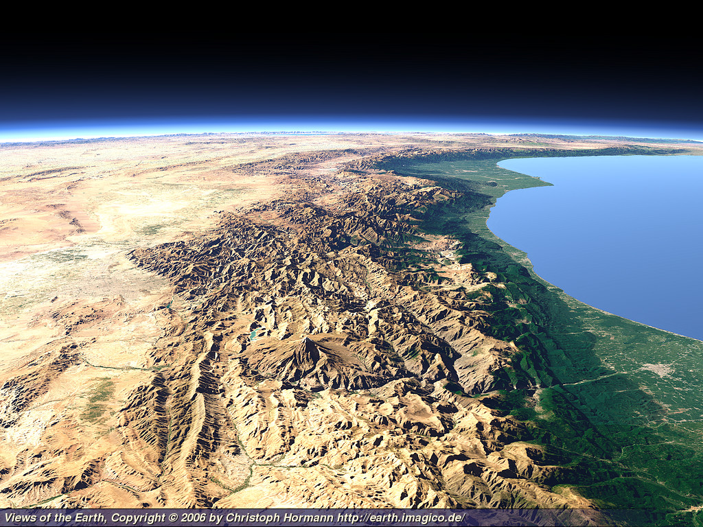
Alborz Mountains in northern Iran is stretching from west to east, in the southern coast of the Caspian Sea. This mountain range forms a natural barrier between the south part of the Caspian Sea and the central plateau of Iran.Elborz Chain is more than 1000 km long and its width varies from 30 to 130 km in different partss, its avarage height is about 3000m, it has several peaks over 4000m.
The highest Mountain in the Alborz Range is Mount Damavand 5671 m which is located in central part of this great mountain range.
The artificial images from northen Iran in this topic are made by Views of the Earth by using computer rendering techniques.

View Full Size Image
Mt Damavand in Alborz Mountains
Caspian Sea and Central Plateau of Iran
Nice work by Views of the Earth
Numerous high peaks are given the name Alborz and some remain till now, ie Mount Elbrus in the Caucasus Mountains and Mount Elbariz (Albariz) in the Kerman. Even there is a peak in the Hindu Kush, near Balkh, called Mount Elburz, these names come from Iran Alborz Mountain. Hike Damavand Iran.
Alborz range is made of sedimentary series. In its northern slopes in the Caspian Sea area, forests ecoregion are lush and forested. Because of its great snowy winters there are several ski resorts, which some are among the best in the word, most important pists are: Dizin, Shemshak, Tochal, Darbandsar and Mt Damavand suitable for off-pist and wild ski mountaineering.
Other Names and Spelling
Alborz in Farsi, البرز, Alburz, Elburz or Elboroz.
View Full Size Image
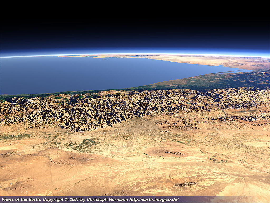
Damavand Volcano in Central Part of Alborz Mountains
Image by Views of the Earth
رشته کوه های ایران کدامند؟
بخش بزرگی از سرزمین ایران کوهستانی است. رشته کوه های البرز و زاگرس دارای قله های مرتفعی هستند که بیش از یکصد قله آن بالاتر از چهار هزار متر از سطح دریا ارتفاع دارند. بیش از نیمی از مساحت ایران را كوه فراگرفته و بقیه آن شامل جلگه ها، دشت ها، دریاچه ها، و بیابان ها و نمكزارها است . كوه های ایران به چهار رشته شمالی، زاگرس، مركزی و باختری (شرقی) تقسیم می شوند. رشته کوه البرز و رشته کوه زاگرس وسیع ترین نقاط کوهستانی ایران هستند. کوههای ایران در چهار رشته اصلی ۵۴ درصد از مساحت کشور را پوشاندهاند.رشته کوه البرز
رشته شمالی یا رشته کوه البرز كه درازای آن به حدود یکهزار كیلومتر میرسد و مساحتی و حدود سه درصد مساحت ایران را زیر پوشش قرار داده است، این رشته کوه بخشی از چین خوردگی های بزرگ آلپ و هیمالیا است. سلسله جبال البرز از استان اردبیل شروع شده، از جنوب دریای خزر می گذرد و در خراسان به كوه های شرقی ایران می پیوندد. بلندترین کوه ایران یعنی قله دماوند با ارتفاع 5671 متر از سطح دریا در این رشته کوه جای دارد. كوه های دیگری چون علم كوه (4650 متر)، سیالان (4175 متر)، پالون گردن (4375 متر) و شاهوار (3945 متر) نیز در همین رشته قرار دارند.رشته کوه زاگرس
رشته کوه زاگرس كه بزرگترین و طولانی ترین رشته كوه های ایران است، از آذربایجان شروع و پس از گذر از استان های كردستان، همدان، كرمانشاه، ایلام، لرستان، خوزستان، چهارمحال و بختیاری، كهگیلویه و بویراحمد ، بوشهر و فارس و هرمزگان تا شمال تنگه هرمز ادامه می یابد و در آنجا به رشته كوه های مركزی ایران و رشته ارتفاعات مكران می پیوندد. رشته كوه های زاگرس با درازای حدود یکهزار و پانصد كیلومتر، مساحتی معادل بیست درصد مساحت كشور را زیر پوشش قرار داده است. بلندترین قله رشته کوه های زاگرس، كوه دنا نام دارد كه ارتفاع آن 4400 متراست. از دیگر كوه های بلند كوهستان زاگرس می توان كوه های شاهور (3300 متر)، پرو (3350 متر)، الوند (3580 متر) اشترانكوه (4050 متر)، زردكوه (4220 متر) را نام برد.
رشته كوه های مركزی ایران
در امتداد قطر بزرگ ایران یعنی از شمال غربی به سوی جنوب شرقی رشته كوه های مركزی ایران كشیده شده و استان آذربایجان شرقی را به كوه های سیستان و بلوچستان متصل می کند. طول رشته كوه های مركزی حدود یکهزار و پانصد كیلومتر و مساحتی برابر نه درصد مساحت كشور را شامل می شود. كوه هزار با بلندی 4465 متر مرتفع ترین قله این رشته کوه است و كوه های لاله زار (4351 متر)، جوپار (4135 متر)، پلوار (4233 متر) و شیركوه (4000 متر)، از دیگر كوه های بلند این رشته هستند. .رشته كوه های شرقی ایران
رشته كوه های ناپیوسته ای بنام كوه های خاوری (شرقی) ایران هستند كه از شمال خراسان آغاز می شوند و رو به جنوب تا استان سیستان و بلوچستان یا كوه های مكران ادامه می یابند. كوه تفتان با ارتفاع 3940 متر بلندترین كوه این رشته محسوب می شود و كوه های چهل تن (3013 متر)، بینالود (3211 متر) و هزار مسجد (3040 متر) از دیگر كوه های مهم آن به شمار می روند. علاوه بر رشته كوه های چهارگانه بالا، كوه های دیگری به طور پراكنده در گوشه و كنار كشور وجود دارد كه عمده ترین آنها رشته كوه های نسبتاً مرتفعی هستند كه دشت كویر را از كویر لوت جدا می کنند. كوه نای بند با ارتفاع 3009 متر بلندترین قله این گروه به حساب می آید. بیشتر بخوانیم
View Full Size Photo
Alborz Mountain, Caspian Sea Green north of Iran
Sepid Rood, Forests Ecoregion
Image by Views of the Earth
رشته کوه البرز
این رشته کوه که در شمال ایران قرر دارد در فاز کوهزایی آلپی در دوران سوم زمین شناسی تکوین یافته و شامل قللی مرتفع و دره هایی عمیق فراوانی است. البرز از سمت غرب از جمهوری آذربایجان شروع شده و در سوی شرق تا ترکمنستان و افغانستان ادامه دارد. بخش بزرگی از کوه البرز در کنار سواحل جنوبی دریای مازندران امتداد دارد. در این بخش، جبههٔ شمالی رشته کوه البرز بسیار سرسبز و جنگلی و جبههٔ جنوبی آن کم آب، خشک و کویری است. دلیل اصلی این دوگانگی وجود رشته کوه بزرگ البرز است که همچون سدّی طبیعی از عبور رطوبتِ برخاسته از دریای مازندران به سوی جنوب جلوگیری میکند و بیشتر این رطوبت در جبههٔ شمالی البرز بصورت باران میبارد. .بلندترین قله رشته کوه البرز و ایران، قله دماوند با ارتفاع 5670 متر از سطح دریا است که در استان مازندران و در مجاورت روستای پلور قرار دارد. دامنهها و درههای رشته کوه البرز از تفرجگاههای مهم مردم همجوار است. از پرآب ترین رودهای این رشته کوه، سفیدرود، کرج و جاجرود را میتوان نام برد. کوههای زیادی برای ورزش کوهنوردی و اسکی در رشته کوه البرز وجود دارند مانند: کوه دماوند، علمکوه، خلنو، آزادکوه، شاهالبرز، سیالان و توچال..
ویژگیهای زمینشناسی و جغرافیایی البرز
از نظر چینهشناسی و زمینساخت (تکتونیک) رشته کوه البرز در سه بخش تقسیم بندی و نام گذاری شده است: البرز باختری از رودخانه آستاراچای تا دره سپیدرود. البرز مرکزی از دره سپیدرود تا دره فیروزکوه و رود تالار. البرز خاوری از دره فیروزکوه تا گرگانرود و مرز خراسان. البرز باختری بخش مهمی از کوههای تالش را در برمیگیرد.آب و هوای البرز
رشته كوه ه البرز یك ناحیه كوهستانی است. دامنه رشته كوه های البرز دارای آب و هوای مناسب و رودخانه های فراوانی است. پیشبینی و هشدار سریع سازمان هواشناسی. بارش برف، وزش باد و افت شدید دما در قلههای رشته کوههای البرز و زاگرس پیشبینیپراکنش خزندگان و گونههای دوزیستان در البرز
رشته کوه البرز از مناطق پراکنش خزندگان و دوزیستان است.
View Full Size Picture
Alborz Mountain Range Caspian Sea and Central Plateau of Iran
Image by Views of the Earth
سوالات متداول
رشتهکوه البرز کجاست؟سلسله جبال البرز رشته کوهی در بخش شمالی ایران استکه از غرب تا شرق کشور ادامه دارد. رشته کوه البرز در بین دشت مرکزی فلات ایران و نوار ساحلی خزر مامن دهها قله زیبا و فراموش نشدنی است.
رشته کوه های ایران کدامند؟
رشته گوه البرز، رشته کوه زاگروس، رشته كوه های مركزی ایران و رشته كوه های شرقی ایران.
قله های معروف رشته کوه البرز را نام ببرید؟
Damavand 5671 M
Alam kooh 4850 M
Kholrno 4375 M
Azad kooh 4355 M
Siyalan 4185 M
Shah alborz 4125 M
Dobarar 4072 M
Tochal 3933 M
Mount Damavand: Comprehensive Guide to Iran’s Iconic Peak – Facts, Figures, and More
Mount Damavand, a majestic volcanic peak located in northern Iran, stands as the highest mountain in the Middle East and the tallest volcano in Asia. Rising to an impressive 5,671 meters (18,606 feet) above sea level, this iconic summit attracts climbers, adventurers, and nature enthusiasts from around the globe. Located in the Alborz mountain range, it offers breathtaking views, unique geothermal features, and diverse flora and fauna. This guide covers everything you need to know about Mount Damavand, including its geographical location, climbing routes, weather conditions, and cultural significance. Discover essential tips for trekking, camping, and planning your journey to this extraordinary peak. Whether you’re an experienced climber or a curious traveler, Mount Damavand promises an unforgettable experience amidst nature’s wonders.
Damavand Camp
Known by several names, Damavand Camp is also called the Damavand Base Camp, Damavand Camp II, or the second camp on Mount Damavand. Locals refer to it as Goosfand-Sara (گوسفند سرا ), meaning "sheepfold," or the Saheb al-Zaman Mosque (مسجد صاحب الزمان ) campsite. This location is a vital checkpoint for climbers and hikers before they make their ascent, providing basic necessities and shelter.
As the most popular and accessible starting point for Mount Damavand, this camp offers essential facilities, including a mountain refuge, the Saheb al-Zaman Mosque, and a sheepfold. Sitting at an elevation of 3,040 meters, with coordinates of Latitude 35.9020° and Longitude 52.1094°, it’s the primary base camp for climbers on the south route, especially during the summer. This camp provides an important resting and preparation spot before the climb.
Best Trekking Tours for Mount Damavand
The best trekking tours for Mount Damavand offer a range of options suitable for both novice hikers and seasoned climbers. These guided trekking and hiking tours provide an all-inclusive experience, encompassing meals, accommodations, and expert guides throughout the journey. The South Route is a popular choice for its accessibility and stunning vistas, allowing trekkers to fully immerse themselves in the natural beauty of Damavand. With multi-day trekking tour packages, you can explore the breathtaking landscapes while developing your hiking skills, ensuring a rewarding experience on your adventure to the summit of this iconic mountain.
Certified Local Damavand Peak Hiking Guides
Certified Iranian Local Mountain Guides for Trekking and Climbing Mount Damavand, Iran. Climbing Mount Damavand can be a daunting task without proper guidance, which is why hiring certified Iranian local mountain guides is crucial. These guides are experienced professionals who know every inch of the mountain, from the challenging slopes to the most scenic views. Whether you’re an experienced climber or a first-timer, a local mountain guide offers a personalized approach to your climb, ensuring safety and providing guidance through every stage of the trek. Their deep understanding of the mountain’s terrain, weather patterns, and potential hazards ensures your experience is both safe and rewarding. Many of these guides offer both private and group tour packages, giving climbers the flexibility to choose the Damvand tour style that suits them best.